
Hungary


Hungary uses long white standard European licence plates. Taxi licence plates are yellow.
In July of 2022, Hungary switched to this new character format, which contains the coat of arms.
NOTE: Newer electric vehicles have green plates.

Hungarian bollards are black-and-white, wedge-shaped, and typically have a red reflector at the front, and a white reflector at the back. Blue reflectors are also somewhat common.
NOTE: Croatian bollards are very similar. They do, however, typically have the reflector closer to the top, and appear somewhat thinner than in Hungary.

The most common type of utility pole in Hungary is a concrete holey pole, with relatively thin holes going all the way down to the ground. Wooden poles are also somewhat common.
NOTE: In eastern Europe, Poland and Romania also commonly use holey poles. Polish holey poles typically do not have holes down by the ground, and tend to be relatively thin. Romanian holey poles normally either have much wider, or much taller holes.
Hungarian chevrons are white on red.
Black-and-white chevrons may also be seen, but are considerably less common.

The Hungarian language has a unique look, with a very large number of acute accents, umlauts over o’s, and long words. The letters "Ő" and "Ű", with double acute accents, are unique to the language.
NOTE: Hungarian is also spoken in some parts of neighbouring countries: notably there are large Hungarian-speaking communities in central Romania and southern Slovakia.

Hungarian street names typically end with the word “utca”. The word “út” is also used for bigger roads. These two words are unique to Hungarian, and translate to “street.”

These green kilometre markers can be seen along most Hungarian roads.
On highways, the numbers correspond to the ones seen on the map in small yellow boxes near exits.

Hungarian sign posts commonly appear to be abnormally tall, often taller than the Street View camera.

Hungarian signs are usually bolted to the sign post using four bolts, going through the sign, in the shape of a tall rectangle.
NOTE: This is not common in any other Eastern European countries.

Hungarian pedestrian crossing signs have five stripes. The person is wearing a belt. There is also a second, less common, type with four stripes and the person holding a bag.
The belt is located noticeably low on the person’s body, almost as if the person is sagging his pants. This is unique to Hungary.
NOTE: Among neighbouring countries, Croatia and Slovakia also have five stripes and a belt.

Apart from European highways, there are two types of numbered roads in Hungary; roads marked with green signs, and highways beginning with the letter ‘M’, marked with blue signs. These road numbers are contained within a small shield shape on the sign.

Most directional signs are green, having a white inner border and a green outer border. Directional signs on M-numbered highways are blue, having a white inner border and a blue outer border.

It is somewhat common to see a small, grey flag on the antenna of Generation 3 Google cars in Hungary.
NOTE: This is also seen in the Czech Republic, Slovakia, Romania and Bulgaria.

The majority of Generation 3 coverage in Hungary was taken during winter, resulting in very grey, dead looking coverage.
HINT: This is also common in the Czech Republic and Bulgaria.

Hungarian houses are typically made of stone, painted in a light colour and almost always with red tiled roofs. Suburban houses are typically only one storeyed, while more central houses may be taller. Houses in town and city centres are often fairly old but well-kept.

While Hungarian road lines are all-white, lines on bicycle lanes are typically yellow.

Hungarian phone numbers consist of either 8 or 10 digits. If the number has 8 digits, the first and second digit is the area code. And if the number has 10 digits, the third and fourth digit is the area code. The only exception is Budapest, where only the first or third digit, being a 1, respectively is the area code.
NOTE: Area codes whose second digit is 0 or 1 are not region specific.

The first digit of Hungarian numbered roads are ordered in a circle, centred around Budapest. Remembering this system should make it quite easy to find any numbered road.

Many Hungarian town names use local prefixes, the most common of which are shown in this infographic. Note that some rare exceptions exist.
You can click on the image to enlarge it.

If you see a street sign with a thick metal frame around it, you are very likely to be in the western parts of the country.

If you see a blue or green street sign shaped like an arrow, attached to a utility pole or street light, you are likely to be in the county of Szabolcs-Szatmár-Bereg.
NOTE: Blue arrow-shaped street signs can also be found in Dunakeszi, north of Budapest. However, those are attached to blue sign posts.

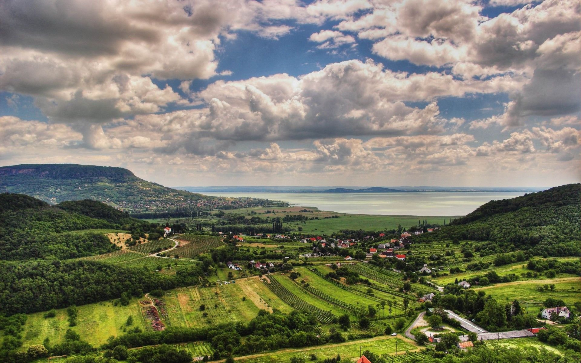
While the southeastern parts of Hungary are extremely flat, with almost no noticeable hills, the northern and western parts mainly consist of forested hills and mountains. The tallest mountains are found in the north, while the southwestern mountains are generally slightly lower.
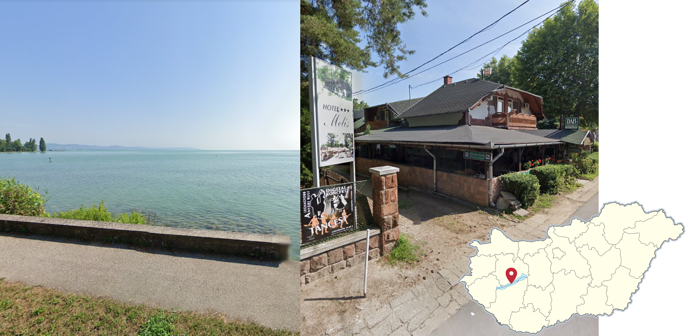
Lake Balaton is one of the largest lakes on mainland Europe, and the only large lake visible on street view in Hungary. The area surrounding the lake is moderately hilly, fairly built up and a big tourist destination, with a much higher density of small hotels than almost anywhere else in the country.

Unlike most of the Hungarian plains, which is almost entirely cultivated land, the Puszta, centred around Hortobágy National Park, mainly consists of barren and wet, natural grasslands.
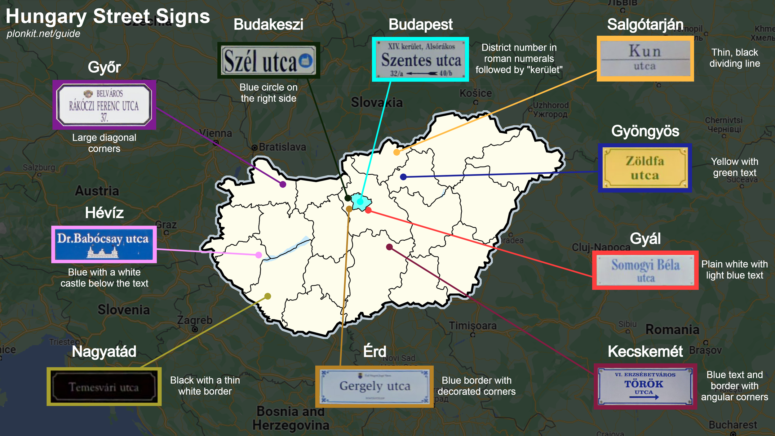
This infographic showcases ten of the largest towns and cities with unique street signs, and explains what makes them unique.
You can click on the image to enlarge it.

The road east of Tornanadaska, right by the border to Slovakia, can be easily recognized by the snow on and along the road, combined with the bollards and the railway right next to the road.
GeoGuessr’s own official maps are not very good, for a variety of reasons. Plonk It recommends you play these maps instead:
In addition, here are some resources to help you practise Hungary:
Plonk It Hungary (map link) - This map contains locations for practising each meta in the Plonk It Hungary guide from step 2 to 3.