
Kenya

Kenya has many unique Google cars, almost all of which will have visible car meta. In Generation 3 you will typically see a car with a roof rack and a snorkel. In Generation 4 you will always have a large pickup truck, which will either be white or grey. The grey car comes in two slightly different variations, of which one can either be with or without a snorkel.
It is the only country other than Mongolia with a snorkel.
NOTE: You can see National Park Cars in other countries with a snorkel on the front of the vehicle. Each vehicle will have its own distinct look.

On a lot of the coverage you will see a grey Toyota SUV following the Street View car.

Kenya uses long white front licence plates. The rear counterpart is square and yellow.

This mobile network brand named Safaricom is unique to Kenya, and almost every city has one location.

Outer lines in Kenya will always be solid white, while inner lines will be yellow and either solid or dashed.

Directional signs are green with a white border and text. They often display road numbers in white or yellow.

While infrequent, road signs in Kenya will mostly be red and white.

Upon closer inspection of signs, billboards and posters, you will notice that the county name is often written. Therefore, knowledge of Kenyan counties can be extremely useful in region guessing.
You can practise Kenyan counties using the quiz in the resource section.

These repurposed vans can be found all over Kenya.
NOTE: While these vans can also be found in Uganda, the design of the vehicle wrap is clearly different.

Many species of eucalyptus are commonly found in Kenya. They can be identified by their long, often clumped leaves, and smooth bark.
NOTE: Eucalyptus trees can be found in other countries. Use this information to help reinforce your country guess

While the vast majority of Kenyan car coverage has a visible Street View car, it is possible to find Generation 3 coverage with no visible car.

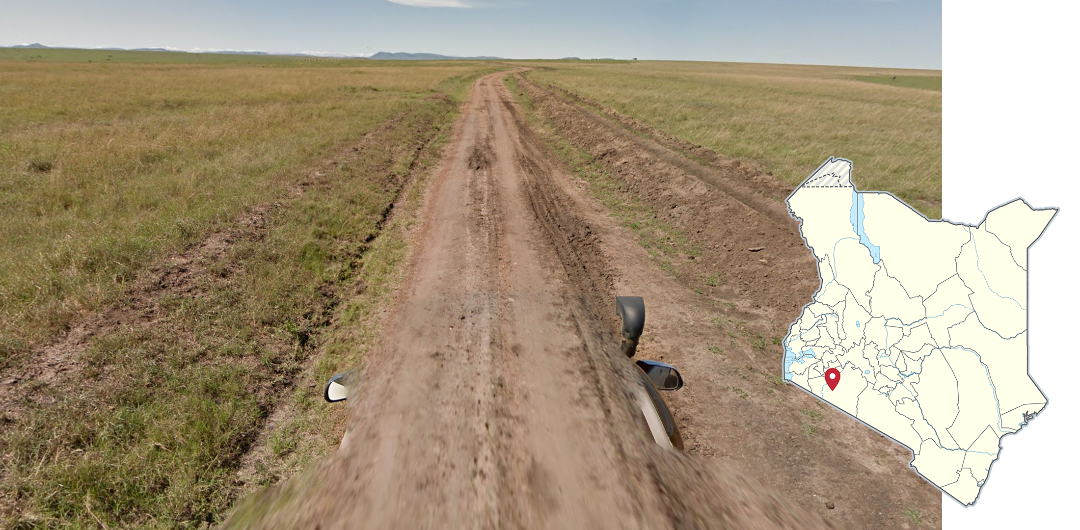
Most of the coverage in Kenya outside of the southwest is limited to main roads.
You can click on the image to enlarge it.

The natural formation of land has great diversity between regions. The east and large portions of the north are extremely flat. In contrast, the further southwest you travel, the higher the elevation becomes on average.
You can click on the image to enlarge it.


This Generation 3 grey car with a large snorkel is mostly found in the west, but can also be found in the Mombasa and Nairobi areas, and regions east of Nairobi near Kitui.
NOTE: Most Generation 3 coverage has been overridden by Generation 4.

This Generation 3 black car with a small snorkel is mostly found in the east of the country. You can also see it north and south of Nairobi.
NOTE: Most Generation 3 coverage has been overridden by Generation 4.

Kenya has mostly Generation 4 coverage covered by a large grey Google car, with or without a snorkel. There are many metas regarding Generation 4, too many in fact to break down here.
RESOURCE: Therefore, please use this document. It covers this area in depth, and was created by snowf_lake#9088.
Key meta information can be found in the tips below. Other less extensive, but still noteworthy car meta, can be found in the spotlight section.

You can see pieces of white tape on the roof of the Google car in a lot of the coverage north and south of Nairobi.

The A109 between Mombasa and Nairobi has light orange dirt and many hills around the road and in the distance. You will additionally see many transportation trucks delivering various goods.
Most of the coverage between Mombasa and Emali also has a unique car, which has a cord on the left.

Mombasa and the other coastal towns are easily identified from the white sandy soil, palm trees and coastal feel.

The far west areas of the country that are northwest and southwest of Kisumu are the most agricultural parts of the country. You will often see farms, grassy hills, and tall eucalyptus trees in this region of the country.

The area around Kitui is semi-arid, usually mountainous, and has light orange, sandy dirt.

The northwest part of the country has very limited coverage, most of which is on the A1 or in Sibiloi National Park. It has faintly tan soil and sparse low trees. A lot of the coverage in this area is very flat, but you can also see hills or mountains.

Kenya has many unique Google cars in and around its National Parks and Reserves. These are still identifiable by the snorkel which is present in almost all of them.
Many of the National Park and Reserve cars must be used in conjunction with landscape, as they can be found in multiple areas.
You can learn more about these National Parks and Reserves in the spotlight section.

The B9 in the Northeast is entirely unpaved and has bright reddish orange dirt with many trees surrounding the road. Most of it is very flat, but the coverage at the western end of the road can have hills and mountains. The soil also transitions into a more sandy colour.

The A2 between Isiolo and Marsabit has many plants alongside the road and you will often see large mountains in the distance. The stretch going through Namunyak Wildlife Conservation Trust will have a very large mountain range to the west.

North of Marsabit will be much flatter, with some mountains in the distance. The stretch just north or Marsabit will have mountains visible to the south, while further north, a different range can be seen. It will also have much less vegetation.

The A3 north of Garissa is very unique, with light coloured soil and many green trees on either side of the road.

The western part of the C34 is a flat, east to west road. There are two long, straight sections with an abundance of sugar cane. Furthermore, you will see a large mountain range north along the entire mentioned stretches of road.

This car that is covered in specks of dirt is unique to these stretches of the A3, B9, and the Habaswein-Dadaab Road connecting the two.

Nairobi is the largest city in the country, and capital of Kenya. It is the only city to have a considerable amount of skyscrapers, and is highly developed. It is densely populated, and is surrounded by small, poor settlements.

In a lot of the coverage north of Mt Kilimanjaro, the mountain is visible to the south, usually obscured by clouds. In the city of Oloitoktok, the mountain will often be visible directly to the south.
NOTE: The map shows the location of Mt Kilimanjaro, but it can be seen from very far away.

Homa Bay has this protruding hill to the east that is often visible.
Mara Triangle has no considerable mountains and most of it is either flat or hilly. It has a white car that can be found in other Kenyan National Parks. Generation 4 coverage exists there as well.

Amboseli National Park has a grey car with a small snorkel. It is very flat with tan grass, few trees, and dried up lake beds. You can always see the base of Kilimanjaro to the south, with most of it obscured by clouds.

Aberdare National Park has a grey and brown car that features a large snorkel. Almost all of the coverage is outside of the National Park, with only two roads within the park covered. The main road through the park has these rubber bands on the roof rack, which can only be found in one other National Park in Kenya.

Between Kitale and Mt Elgon, you can find the Aberdare car as well, but it will always have rubber bands, unlike in Aberdare where it will only have them on the main roads through the park. It can be differentiated from Aberdare by its redder dirt, and greener landscape.

The area surrounding and between Kerio and Lodwar uses the same car as the Aberdare National Park, but with a vastly different landscape. It is very sandy, dry, and has little vegetation.
You may also find yourself in Generation 3 coverage without car meta.

This stretch of the B8 just north of Kibaoni has many succulents on the side of the road.
GeoGuessr’s own official maps are not very good, for a variety of reasons. Plonk It recommends you play these maps instead:
A Balanced Kenya (map link) - A well balanced, computer generated map of Kenya with over 50,000 locations.