
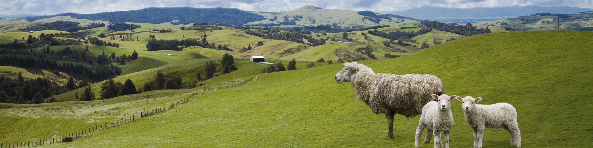
New Zealand


Bollards in New Zealand have a red strip which wraps around the top of the bollard. This strip wraps the whole way around the back and part of the front. The front or back of the bollard often contains a thin yellow or white reflector.
NOTE: These bollards are unique to New Zealand.

New Zealand uses white licence plates with black text, which appears mostly white through the blur.
NOTE: Some vehicles have custom licence plates which make the sides of the licence plate appear blue or black.

The most common pole type found in New Zealand is made of concrete and has one long indent which runs most of the way up the pole. Most concrete poles have small silver possum guards. Circular wooden poles can also be found, but are less common. You can also see concrete holey poles in New Zealand.

Give-way signs in New Zealand have a white border and red text.
NOTE: Australia’s give-way signs use black text.

New Zealand intersections often use give-way triangles painted on the road.
NOTE: Australia does not use this design.

The majority of directional and warning signs in New Zealand are held up by white posts. Warning signs are diamond-shaped and painted yellow.

New Zealand often uses blue street signs with white text, particularly in rural areas. While street signs of other colours can be often seen, blue is by far the most common.
NOTE: Australia almost never has blue street signs.

New Zealand normally uses white outer road lines. Yellow dashed outer road lines can be seen in populated areas. Roads with no outer lines can be seen on smaller roads. Inner lines are either a single dashed white line or unbroken double yellow lines.
NOTE: Australia does not have yellow inside lines, apart from regions with snow.

New Zealand uses black-on-yellow chevrons with a thin black border. White on black chevrons are very rarely used.
NOTE: Australia’s chevrons have the same colours, but do not have the border.

New Zealand uses green directional signs. If the sign is on a state highway, the highway number will always be shown in a red crest.
NOTE: Brown signs indicate the direction to landmarks, which can be useful when pinpointing.

Bridge markers can be found on most paved roads in New Zealand. If the sign is on a state highway, the highway number will always be shown in a red crest on a white marker. The yellow marker indicates the name of the river or bridge.
NOTE: Some bridge markers indicate very small streams or culverdens which can be hard to find.

It is very common to see ferns growing in forested areas in New Zealand.

Two-digit state highway numbers follow a sequential pattern from North to South, making them easy to find. Single digit highways run through large parts of the country, but are easy to remember due to the small number of them.
NOTE: Bollards can sometimes have highway numbers written on them.
You can click on the image to enlarge it.

New Zealand phone numbers are seven digits with a two-digit area code in front of it. Numbers starting with 02 are mobile numbers.

The first digit of Fonterra farm signs follows the regional pattern seen on the map.
This image was provided by snowf_lake and brainy. You can click on the image to enlarge it.

The cities of Auckland, Wellington and Christchurch all have unique bus stop signs.
You can click on the image to enlarge it.

Several New Zealand cities have distinctive rubbish bins. The distinguishing feature of the bins are the council logos on the front. The colour of the bin lid varies within cities.
NOTE: It is rare to find bins with green lids outside of Christchurch.
You can click on the image to enlarge it.

The Waikato and Northland regions are characterised by their drier climate and rolling hills. In particular, the Northland region is quite hilly.
NOTE: This type of landscape can be found in other parts of the North Island, but is more common in the mentioned regions.

The West Coast and part of the Tasman region on the South Island can be recognized by its temperate rainforests and rugged landscape. This can be seen through the hundreds of tall hills and mountains, as well as the dark, compact greenery which is due to the area’s high level of rainfall.

The flatter parts of the Southland and Otago regions can be recognised by their cold climate and sloping, alpine hills. The vegetation in this area is often quite stunted due to the climate.

The Southern Alps, a large, snowy mountain range, stretches throughout the majority of the South Island. Vegetation on the mountains becomes rarer the further south it is.

Hawke’s Bay has dry, golden grassy hills, and in Generation 4 it will be sunny with a white Street View car.

Bright sandy cliffs are a common sight in the central region of Manawatū-Whanganui. They may also be found in parts of Taranaki, Waikato and a road going into Hawke’s Bay.
NOTE: Sometimes the cliffs may appear like sandy rocks.

The area of the Southern Alps, north and south of Queenstown, contains many glacial lakes, which can be recognized by their teal colours and clear waters.

Mount Taranaki, often referred to as Mount Egmont, is easily distinguished due to its relatively smooth slopes and its pointed, often snowy peak. It can frequently be identified from afar, as the surrounding area is flat.

Generation 2 coverage and gravel roads are particularly common in the Northland region.
NOTE: These tips do not exclusively indicate Northland. Be sure to use other clues when making guesses.

Tall hedge and tree rows are particularly common in the Canterbury region. They are mostly found in the Canterbury plains, which comprises very flat, large fields.
Due to Canterbury’s flat landscape, mountains can often be seen in the distance to the west.
NOTE: Hedges that are even taller are common near Tauranga.

Very tall hedges are found in the Bay of Plenty, mainly around Tauranga.
NOTE: Noticeably lower, but still tall, hedges are commonly found in Canterbury.

Vineyards are particularly common in the Marlborough and Hawke’s Bay regions.
NOTE: Vineyards can be found throughout New Zealand, so be sure to check other clues as well.

Corn is almost exclusively found on the North Island.

While New Zealand flax can be found across the country, if you see them in long neat rows, you should consider Southland.

Most utility poles in the Marlborough region have a long square shaped olive-brown possum guard. These can appear alongside the usual shorter silver possum guards.

Many of the utility poles in Southland feature a long cylindrical silver possum guard. These are also more rarely found in western Otago.

Holey poles are found most commonly in Southland and around Auckland.

Square concrete poles without the usual indent are most common in Southland, but can also be found in Otago, Taranaki and Manawatū-Whanganui.

Uneven crossbars, meaning they are off-centre, are found in Otago, Marlborough, Wellington and Taranaki.

Poles with the middle insulator being installed on top of a tall metal bar are often found along the Auckland Waikato border, as well as in other parts of Waikato.
NOTE: Insulators installed on significantly shorter vertical bars are rarer and can be found all across the country.
Some concrete poles in eastern Waikato and Whanganui city have white paint on the middle part of their wooden crossbars. This white painted crossbar can also be found in parts of western Bay of Plenty, Taranaki, Manawatū-Whanganui and eastern Wellington.

A yellow tag, similar in appearance to a cow-tag, is found on most poles in Gisborne. It is also found in a few spots on the South Island, as well as over the border in northern Hawke’s Bay.

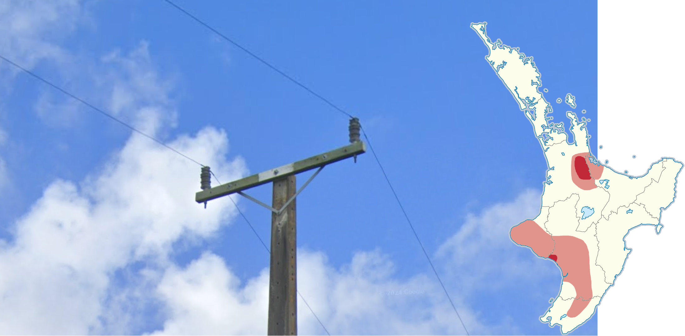
A warning sticker attached to poles, which has a yellow danger triangle between two white rectangles, is found in Hawke’s Bay, from lake Taupo to lake Rotorua, in northern Waikato and south of Auckland city.

A medium sized black vertical sticker with 5 digits is found in West Coast, Tasman, southern Canterbury and southern Northland.

A long black vertical sticker with 6 digits with a small black square beneath it, is found on most of the North Island, in Southland and in Otago. On the North Island the first digit will be a 3 or a 4, while on the South Island it starts with an 8.
NOTE: There is a similar regional black sticker with 6 digits but without a small square below it. Additionally, the sticker can rarely be white.

Poles near Timaru often have a tall rectangle of orange paint on them with the text “DANGER LIVE WIRES”.

A small black horizontal pole sticker, with several numbers, is often found in Taranaki and Wellington. The sticker may rarely be found in parts of Manawatū-Whanganui, Waikato, and southern Hawke's Bay.

Similarly, a small white horizontal pole sticker with several numbers is found in several parts of the North Island.
NOTE: The edges of the plate must be straight, meaning they cannot be rounded. Rounded plates are seen all across the country.

Solid outer white lines without middle lines are most common in Gisborne, but can also be found in northern Hawke's Bay and Wellington.
NOTE: The roads in Wellington are typically narrower.

A typical bollard, but with a green stripe, is common in southern Canterbury, as well as in some pockets in eastern Southland.

A typical bollard but with a black stripe instead of a red one is commonly found in Wellington, especially in older Generation 3 coverage.

Wooden fences with tightly packed fence posts are most common on the Northern Island and the north of the South Island, as well as on Akaroa.
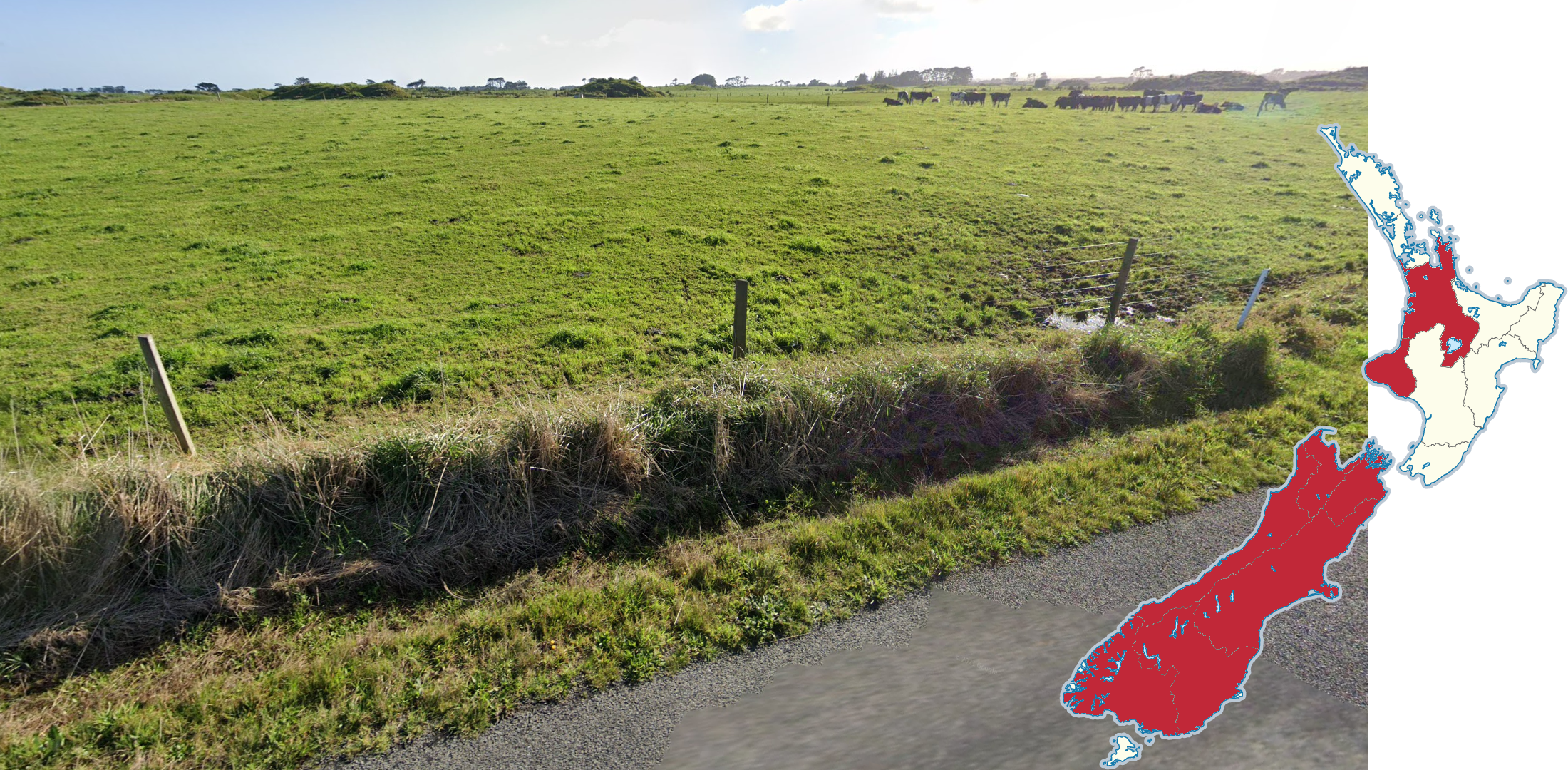
Wooden fences with a big gap in-between them are most common on the South island as well as in Taranaki.

Fences with thin metal fence posts are almost exclusive to the South island.

Short pieces of wood attached to a fence post, slightly extending it, can often be found on fences in Hawke’s Bay and occasionally in Manawatū-Whanganui and Gisborne.

Similar wooden extensions, which are significantly longer, are mainly found in Southland and Hawke’s Bay, but can also be seen in Otago.

This car with a white and blue front is mostly found on the North Island. It can occasionally be found In Canterbury and Marlborough, on the South Island.

This Street View car features a white-blue-white pattern which is blurred out, and is mainly found on the South Island or around and north of Auckland.

There are many town and city specific street signs in northern New Zealand, which can be seen in this graphic.
You can click on the image to enlarge it.

There are many town and city specific street signs in southern New Zealand, which can be seen in this graphic.
You can click on the image to enlarge it.

An easy way to recognize the city of Wellington is by how hilly it is.

Stewart Island only has coverage around the settlement of Oban. It is easily recognized due to the distinct bay, which is often filled with small boats. There is only Generation 3 camera coverage.

The area around Tongariro National Park is identifiable due to the low-lying volcanic vegetation in the area. Mount Ruapehu and Mount Tongariro are in the vicinity, and their tops are often covered by clouds.

Coverage on Mount Ruapehu is easily identifiable due to the dark volcanic landscape and distinct lack of vegetation.
NOTE: This type of coverage is limited to the roads around the Whakapapa Ski Village.

In 2011, Christchurch was hit by an earthquake. As a result, roads on coverage from 2012 often appear in quite bad shape. Water damage caused many driveways to be cut off from streets due to large puddles of water, dirt or mud.
Due to this reason, many residential houses in the city had to be removed, leading to several districts on newer coverage appearing like normal suburbs, but with almost no houses. This is noticeable when looking at where former driveways used to be.

Part of State Highway 85 in Otago has light snow coverage, specifically between the towns of Becks and Morisson.

The cities of Lower Hutt and Upper Hutt can be identified by the wide, green valley they are located in, which runs southwest to northeast.

Blenheim can be recognized by having a large range of hills to the north and the south of the city.

Fruit farms covered in green netting are particularly common near Tauranga, but can also be seen near Gisborne.
NOTE: Fruit farms are not fully exclusive to these regions, so make sure to consider other clues as well.

Banks peninsula, also known as Akaroa, is rocky with grassy hills, and small patches of trees.
NOTE: This region can sometimes have gorse, which are also commonly found on the Otago peninsula.

The region of northern Marlborough, known as Marlborough Sounds, has densely forested mountains protruding from water.
NOTE: Northern Marlborough is almost exclusively in Generation 4.

The Otago peninsula east of Dunedin is recognizable from its combination of plants such as cabbage trees, yellow flowered bushes, small groves of cone-shaped pine trees, and New Zealand flax. Additionally, the peninsula’s poles often have off-centre crossbars.

State Highway 73, located near Arthur’s Pass, can be recognised by the almost dried out river with an abundance of gravel on the river bed. Additionally, the Street View car in Arthur’s Pass drove behind a black pickup truck with two ladders on its roof.

State Highway 94 is characterised by its dense red beech forest surrounded by snow-capped mountains.

State Highway 80 in the Southern Alps is recognizable by its north-south orientation up a glacial valley. The west side of the road is lined with snow-capped mountains, while the east side of the road runs alongside the Tasman River and Lake Pukaki.

The mountains of Pirongia and Kakepuku are often seen together in an otherwise mostly flat landscape. To the west, we have Mount Pirongia which is a long mountain range, with 2 distinct small bumps. Meanwhile Mount Kakepuku is to the south and has a volcanic cone shape.

The volcano of Putauaki in eastern Bay of Plenty has a seemingly cut-off top which vaguely resembles the shape of a frog, with two big “eyes” protruding on either side of the top.
GeoGuessr’s own official maps are not very good, for a variety of reasons. Plonk It recommends you play these maps instead:
In addition, here are some resources to help you practise New Zealand:
Plonk It New Zealand (map link) - This map contains locations for practising each meta in the Plonk It New Zealand guide from step 2 to 3.
The Ultimate New Zealand guide (link) - This guide was written by Brainy, and it contains an extensive list of metas for region guessing New Zealand.
Many pole metas were discovered by Binull.
This guide also sourced many others, including weett’s google car & season meta document.
Pole Markings guide (link) - This guide by Lupus covers many pole plates, stickers and so on. Useful if you wish to master New Zealand.
Street Signs of New Zealand guide (link) - This document by fie summarises all of the regional street signs in New Zealand. Highlights differences between less distinct signs.
Fonterra Farm Guide (link) - Not just the first digit of the fonterra farm numbers are regional. This guide by snowf_lake covers the regions of the 2nd digit.
Several of these resources contributed to the development of this guide.