

Senegal

Senegal is the only African country to use fully blue licence plates. A newer version exists in Generation 4 which looks like the standard European licence plate which is white with a blue strip on the left.

A silver or white truck cab is visible in the Generation 4 coverage. Several variants of each exist, most of which are region or road specific. The most useful and recognizable ones will be shown in the spotlight section. For a complete overview, see this document by Lupus.
In the area around Dakar and Thies you can also find a black pick up truck.
NOTE: The car may sometimes be fully blurred. Make sure to look at the landscape or other clues in the absence of car meta.

A Google Car with a visible roof rack and the right side mirror is seen in Generation 3 coverage. Rifts can also be seen in the sky.
NOTE: This specific Google Car with the right side mirror visible is unique to Senegal. Roof racks and rifts however can be seen in various other countries.
Senegal drives on the right.
NOTE: This is mostly useful to distinguish it from Kenya, which drives on the left. The other countries with coverage in Africa that drive on the right are Ghana, Nigeria, Rwanda and Tunisia.

Being a former French colony, Senegal uses French infrastructure such as bollards, poles, signs and road lines.

The official and most common language seen in Senegal is French.
NOTE: The other sub-Saharan countries with street view coverage use English (Rwanda being a minor exception to this – however landscape should be sufficient to always tell the difference).
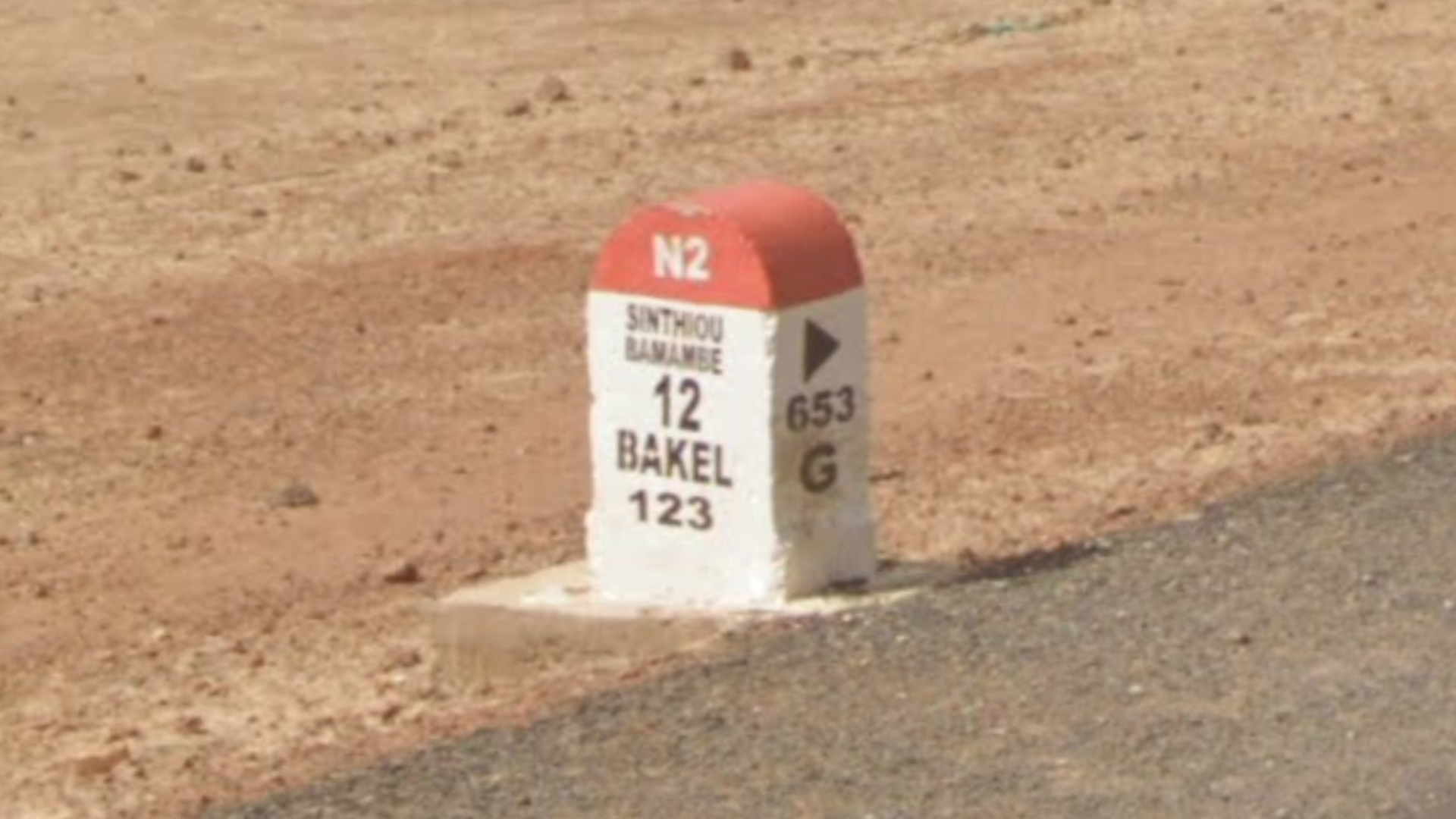
The road number and the distance to the nearest towns can be seen on these white kilometre markers with a red top.
NOTE: The town that is the furthest distance away is usually the largest.

Most town entry signs in Senegal are white and feature a thick pink outline. The town is also written in a bold, black font.

These simple black lamps with a solar panel at the top are commonly seen in Senegal.

Yellow-orange taxis with black fenders can commonly be seen in Senegal.

This is a coverage map of Senegal. Most of the coverage is west of Touba, with very few roads apart from main roads covered in the east.
You can click on the image to enlarge it. Alternatively, you can look at the coverage in more detail on this site.

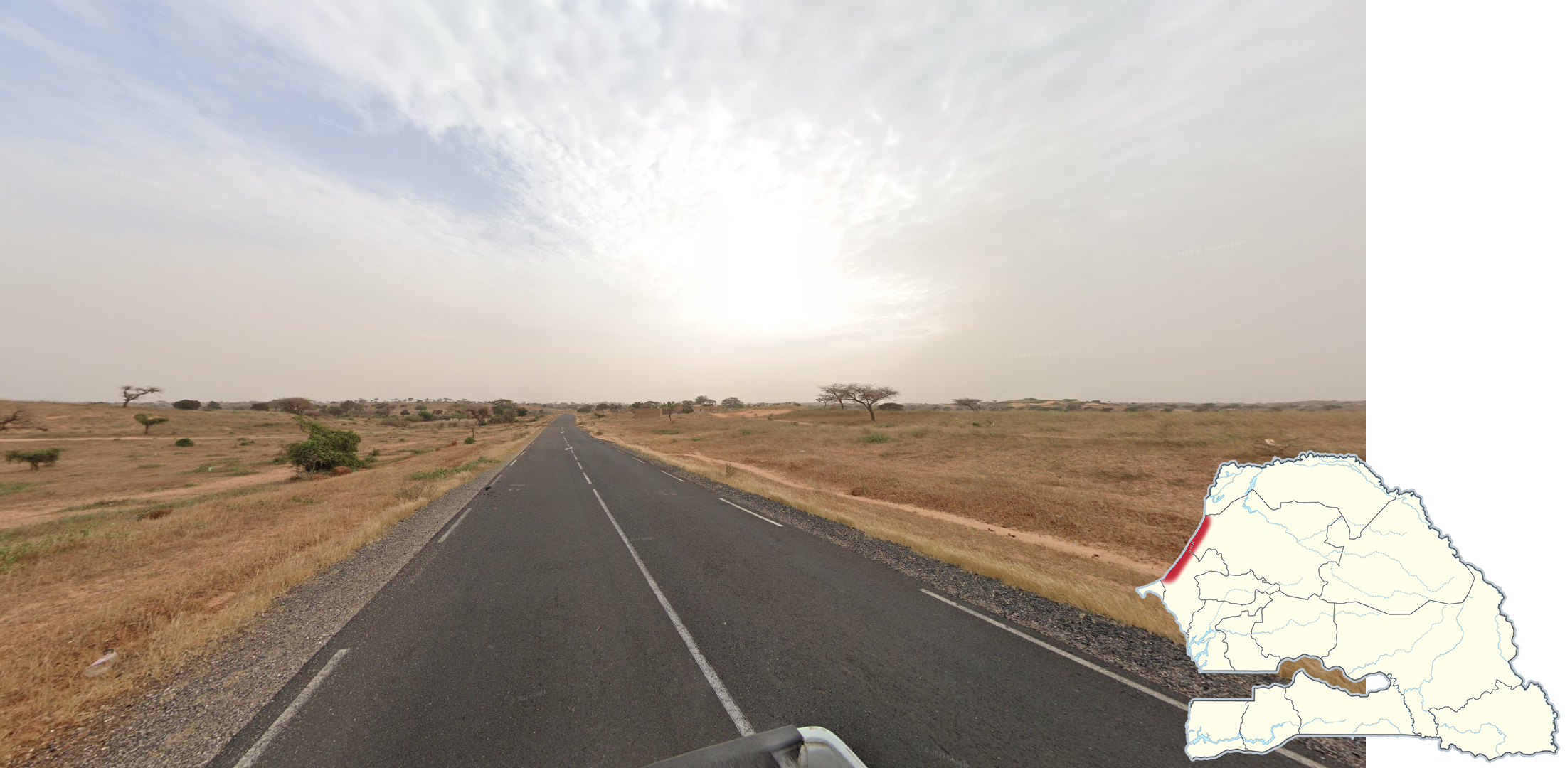
The landscape north of The Gambia and for Senegal generally is a flat, arid, savannah-desert landscape with sparse trees. The trees themselves will be somewhat short and have leaves that are faded in colour.

The vegetation in the region south of The Gambia is more lush and green compared to the rest of Senegal, and palm trees can be seen closer to the coast.
NOTE: Coverage toward the west will also be especially tropical. In addition, make sure not to confuse the south with some coverage near Dakar, which can look deceivingly green. However, here the vegetation will look a lot more low and coastal.

Diourbel Region is the only region in Senegal with extensive rural coverage. The coverage in the region will look like this, with the Google Car driving on a sandy road with sparse trees. Some of the coverage extends to the west in the Thies region up to Babou.
NOTE: The sand in the coverage around Touba tends to be more grassy.
A very slightly rolling landscape consisting of vegetated sand dunes can be seen along the northwestern coast.

A dry landscape with slight hills can mostly be seen around Bakel, but also south to Nayé.

A greener landscape with larger hills can be seen around Kedougou and Mako.

Irrigated rice fields can sometimes be seen in the region between St Louis and Richard Toll.

The silver Generation 4 car with a long antenna at the front left can be seen on many roads, but none past the eastern border of Diourbel Region.
NOTE: The antenna is visible even if the car is blurred.

The regular Generation 4 white car is most commonly found south of The Gambia, but can also be found on the northeastern coast and a small region between Kaolack and Saly.
Roads

Divided highways are found between Dakar and Touba. The two divided highways are between Dakar and Touba, and between Dakar and Saly.
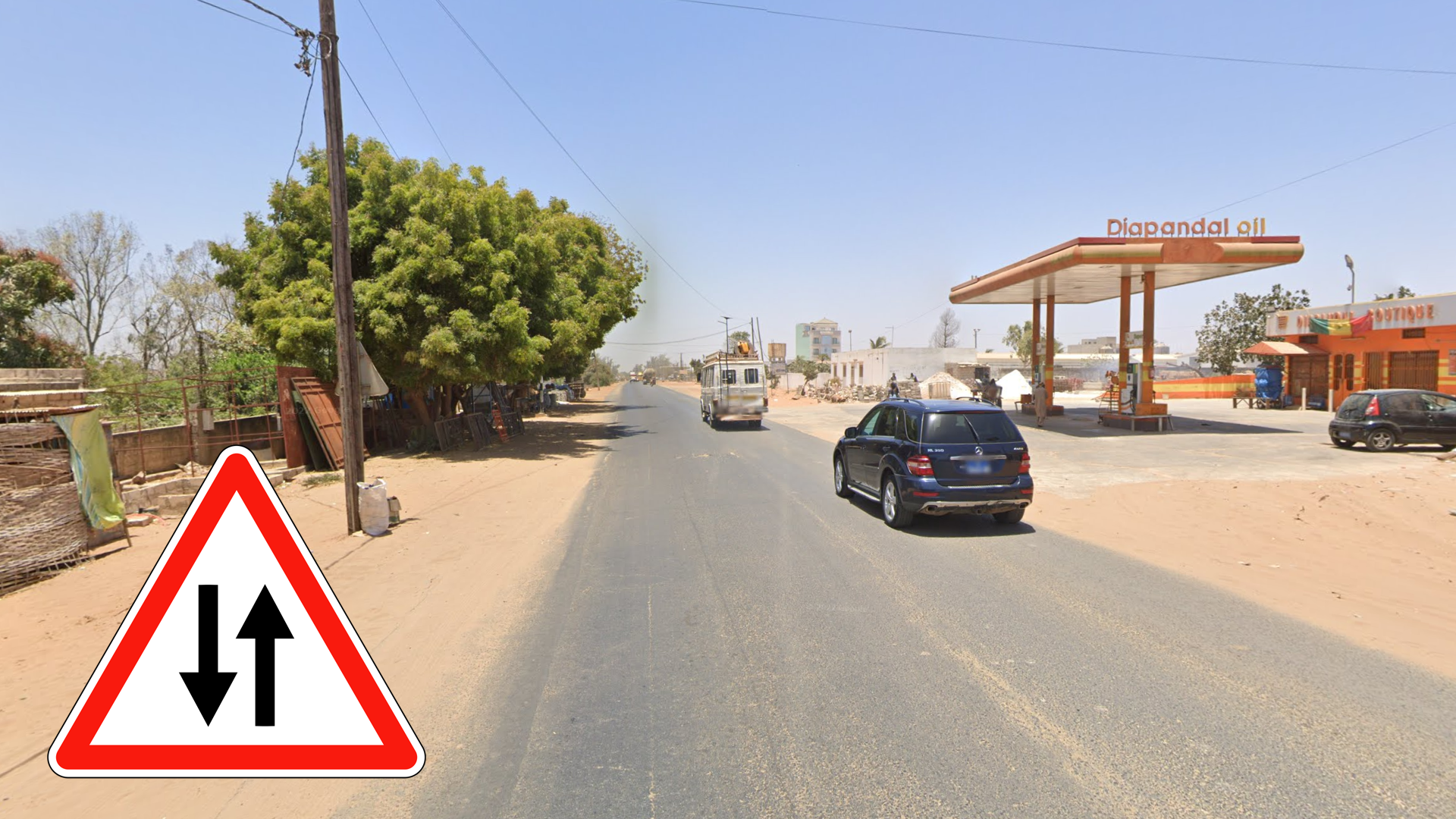
NOTE: On Google Maps, the road shows as a yellow road but without road number. There are also no divided highways in Generation 3.

The N1 between Tambacounda and Nayé generally runs in a northeast east direction. A railway runs parallel to the road. The railway is to the south of the road between Tambacounda to just before Youpe Amadi, and is to the north from Youpe Amadi to Bellé.

Hazy coverage with a low sun through a sometimes agricultural landscape can be seen on the N2 between St. Louis and Richard Toll.

The N2 between Richard Toll and Matam is a wide road going through a flat desert landscape with very sparse trees. It can be recognized by the bright blue skies with no clouds. The road itself goes east-west and northeast-southwest.
NOTE: The higher the sun is, the more east you are.

Distinct, tall patches of bright yellow grass can be seen along the N3, mostly to the east in the Matam Region.

The road northeast of Kedougou to the Malian border can be recognized by the hazy bushfire coverage. Smoke trails can sometimes be seen in the distance. The road is paved south of Saraya.
NOTE: The car is always blurred.

A flat, slightly marshy landscape with low vegetation can be seen on a few sections of roads in the Saloum River Delta.

The Kola-Velingara road between Saré Amirou and Badion is a dirt road that can be recognized by the late afternoon to evening coverage. The coverage gets later toward the west.

The white road in the Forest of Thies can be recognized by the dry, slightly hilly landscape with brown vegetation. The road itself is made of bright orange dirt. There is also a noticeably haze in the coverage.
Cars

The silver Generation 4 car with a box in the back right of the cab can mainly be seen on the road between Richard Toll and Louga, and the N3 between Tiourene and Matam. It can also be seen on the dirt road hugging the Mauritanian border, from Matam to Gassamberi. Finally, it can be seen on a few roads near Diolotène.

The silver Generation 4 car with a stain at the back left of the cab can be seen on the N2 from Richard Toll to Matam and Bakel to Nayé. It can also be seen on the N1 between Tambacounda and Nayé.

The silver Generation 4 car with a stain at the back left and a dirty roof can mainly be seen on the N1 between Kaffrine and Tambacounda, and the N7 between Tambacounda and Kedougou. It can also be seen between Dahra and Diakhao.

The silver Generation 4 car with a red cloth at the front left can be seen on this eastern road between Ouro Sogui and Bakel.

The white Generation 4 car but with the antenna down, parallel to the car’s roof, can be found on the N6 between Ziguinchor and Kolda.

The white Generation 4 car with a noticeably dirty back can be seen on the road going north of Kolda, up to Katonfara.
Towns & Cities

Dakar is the largest and capital city of Senegal. It can be recognized by the denseness of the city and taller, more modern buildings.

GeoGuessr’s own official maps are not very good, for a variety of reasons. Plonk It recommends the following maps instead:
A Balanced Senegal (map link) - A balanced map of Senegal with 100K+ locations. May not be pinpointable.
In addition, here are some resources to help you practise Senegal:
Plonk It Senegal (map link) - This map contains locations for practising each meta in the Plonk It Senegal guide from step 2 to 3.