Taiwan
Taiwan uses Traditional Chinese. It is one of the most complex scripts visible on street view, with intricate characters that consist of many strokes.
NOTE: Hong Kong also uses traditional Chinese characters on signage.
Japanese uses some Chinese characters (kanji), meaning the script can look somewhat similar. However, Japanese will also have a considerable amount of more simplified looking characters (katakana and hiragana).
Poles almost always feature these black and yellow diagonal-striped markings that run all the way to the bottom.
NOTE: Similar markings can be seen in South Korea. However, the markings are much shorter and do not run all the way to the bottom.
Roads in Taiwan generally feature double yellow middle lines with single white outer lines. Thinner roads sometimes use single dashed yellow lines instead.
Taiwan uses these bollards with either two or three circular reflectors on a black rectangle.
You can also find these lollipop looking reflectors on guardrails, similar to the designs found in Japan.
Architecture in Taiwan varies in designs, ranging from cramped, multiple-story housing to flat, single-story houses with backyards. Many residential buildings have a very boxy look. A lot of walls are covered in tiles, usually white. Sheds made out of tin are also featured, commonly painted in a light green colour.
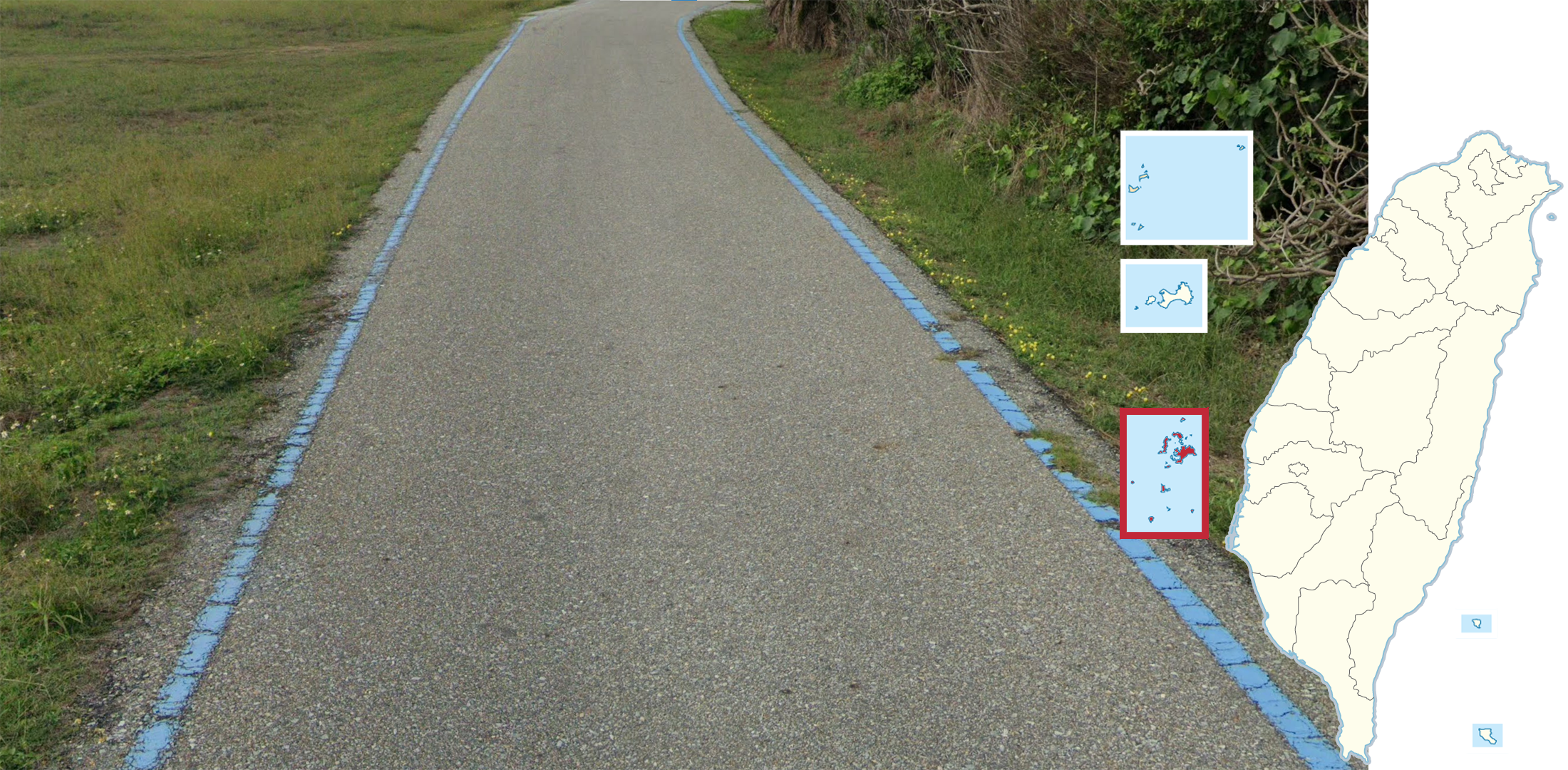
This is a map of the counties of Taiwan. Importantly, Taiwan has a couple of smaller islands and island groups with coverage that are fairly far away from the main island. It is important to be aware of these, as they often catch beginning players off-guard. These include:
Kinmen close to the coast of mainland China.
Lienchiang (Matsu Islands), also close to the coast of mainland China.
Penghu in the middle of the Taiwan Strait.
Green Island and Orchid Island, southeast of the main island. These two islands belong to Taitung County.
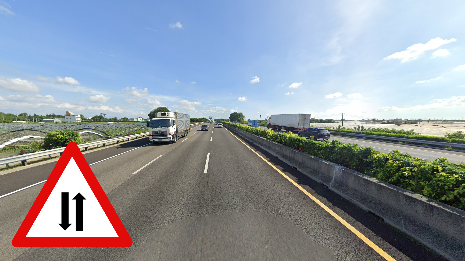
Taiwan’s National Freeway system is organised so that odd numbers represent north-south roads and even numbers represent east-west. Generally, numbers also increase moving west to east and north to south. The 1 and the 3 are by far the longest, running across the west coast.
You can click on the image to enlarge it.
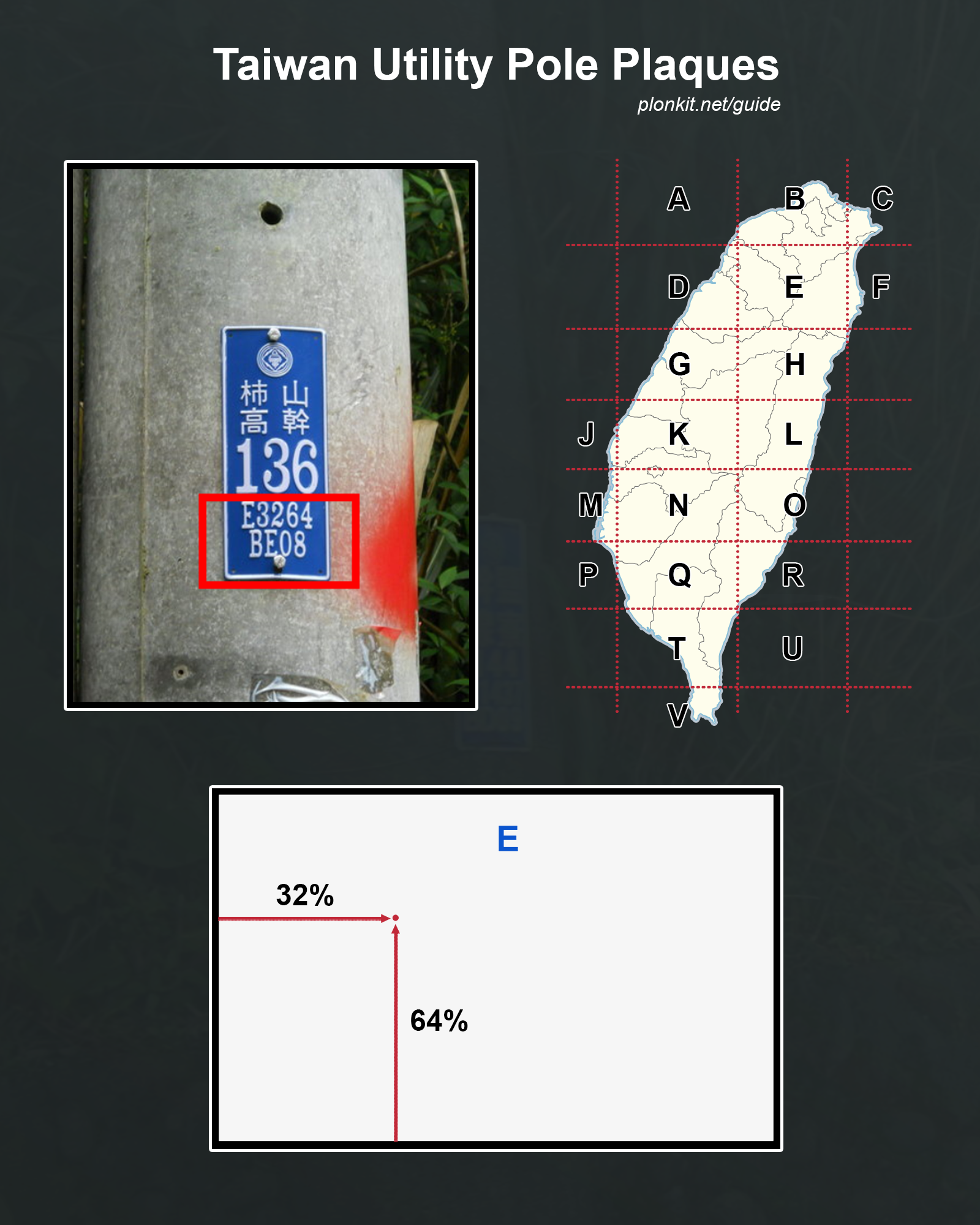
Many poles in Taiwan feature these blue plaques with strings of letters and numbers that act as precise coordinates.
For an example of how to read the plaques in-game, the only thing that is useful here is the string “E3264”. “BE08” can further narrow down the position but is not practical in-game.
“E” refers to the 50x80km rectangle from this map.
“3264” means that within the rectangle, we are 32% eastward and 64% northward.
This article explains how the string “BE08” can be further used to narrow down the exact coordinates of the telephone pole.
Landscape
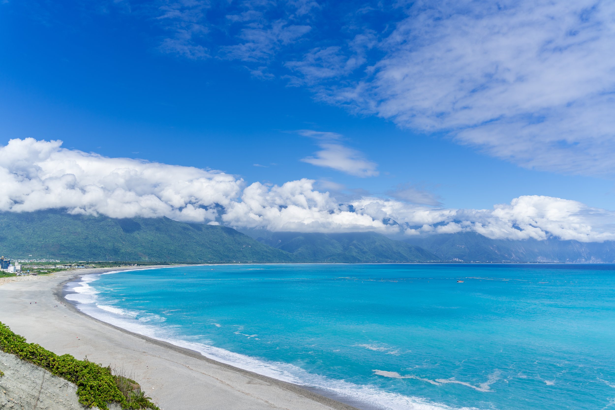
The central-eastern region that covers two-thirds of Taiwan consists of forested mountains.
The central mountain range that runs all the way to the south of the island is made up of tall mountains and rugged valleys. At high elevations, the vegetation can look less tropical and feature temperate or even coniferous trees.
The Hualien-Taitung Valley is a thin and long valley located on the east coast of the island passing from Hualien City at the north to Taitung City at the south. It is very recognizable as it consists of flat gentle plains surrounded by densely-forested mountains to the east and west.
NOTE: Most of the coverage on the east coast lies within this valley.
There are also other valleys in central Taiwan that can look similar.
The Yilan Plain is easily identifiable by the mountain ranges that are seen in the north, west, and south. Rice paddies are also extremely common as well as houses built right next to these fields.
NOTE: While the landscape on the surface can look quite similar to the valleys of Hualien and Taitung, unlike those two, you will almost never find mountains to the east in the plains of Yilan. Furthermore, the flat plains of Yilan are also generally more open.
Agriculture and vegetation
Areca catechu, also known as areca palms or betel nut palms, are extensively found in central and southern Taiwan.
Areca palms are most common in the mountainous regions of Taiwan, you can still see dense areca palm patches in northern counties but they are few and far between.
Coconut palms (Cocos nucifera) are primarily found in the southern-half of the island, toward the coast.
Norfolk island pines (Araucaria heterophylla) are extremely common in the county of Penghu, especially in tightly-packed rows next to roads.
NOTE: While these trees can be found on the main island as well, they are usually never found in such close proximity.
These areca palm plantations are mostly found in the county of Pingtung.
NOTE: Plantations in Pingtung are mainly found in neat, organised rows like these, in the flat plains. While in most central and southern counties, they will be found in the mountainous areas. Additionally, the counties further north will also rarely have areca palms in the flat plains of the west coast.
Architecture
Infrastructure
The islands east of Taitung, Green Island and Orchid Island, are distinct due to the more tropical climate, abundance of coconut palms, and lush cliffs. Additionally, it is common to find run-down, concrete pavement.
NOTE: While the landscape between Green Island and Orchid Island are quite similar, a good way to distinguish the two is that Green Island frequently uses yellow outer lines. Additionally, Green Island is slightly more built-up.
Lienchiang County, also referred to as the Matsu Islands, is recognizable from the hilly landscape and frequent use of concrete roads. The coverage is overcast and this pavement can also commonly be found.
The Provincial Highway 8 that runs from Taichung to Hualien is very recognizable, specifically in the Hualien part, due to the yellow guardrail that can be found all throughout the western half of the road in the county.
The eastern half of the road features these tall exposed-rock cliffs that tower over the road.
The Provincial Highway 20, specifically the part that runs through Yushan National Park, features tall mountains covered with coniferous trees. The road also utilises these tube-like double guardrails.
NOTE: This road is only covered in Generation 2 and 4. The Generation 4 coverage is very overexposed and features sunny weather.
The road that leads up to Taipingshan National Forest in Yilan is distinct due to it often being very foggy when covered. Other features of this road include the coniferous trees and a guardrail with red legs.
NOTE: Certain parts of the roads feature a sunset in Generation 3.
This open landscape with forests of short trees surrounding a narrow grassy road can be found in Hualien in the flat parts of Guangfu and Fenglin. This area can be distinguished due to it being commonly covered in Generation 2; however, you can find similar landscapes in Generation 3 and 4.
GeoGuessr’s own official maps are not very good, for a variety of reasons. Plonk It recommends you play this map instead:
AI gen - Taiwan (map link) - balanced, arbitrarily generated map of Taiwan. 68k+ locations. Not pinpointable.
In addition, here are some resources to help you practise Taiwan:
Plonk It Taiwan (map link) - This map contains locations for practising each meta in the Plonk It Taiwan guide from step 2 and 3.
Taiwan counties quiz (link) - practise the counties’ names and their locations.
Taiwan phone codes quiz (link) - practise the area codes.
Taiwan county road prefixes quiz (link) - practise the characters used for the county road prefixes.
Taiwan electricity poles (map link) - practice map for geolocating using the blue sticker that is found on utility poles.


