
Turkey
NOTE: The official international spelling for Turkey, which is also seen on Google Maps, is Türkiye. This guide however will still use “Turkey” as it is the most commonly used spelling in less formal settings.


Turkey uses the same licence plates as most of Europe: they are long and white, with a blue strip on the left.

The Turkish language has a fairly unique look. It uses the following special characters:
Ç ç and Ş ş with a cedilla (“hook” below the letter).
Ö ö and Ü ü with an umlaut (two dots).
Ğ ğ with a breve.
Dotless I ı. This letter in particular is noteworthy, as it is essentially unique to Turkish. In case you are confused: this is similar to the letter i, but without a dot when written in lowercase.
Capital İ with a dot.

Turkish bollards have a simple design: rectangular, plain white, and with a red reflector on the front. They are thin when seen from the side.
NOTE: Romania has similar bollards. However, bollards are relatively rare in Romania.
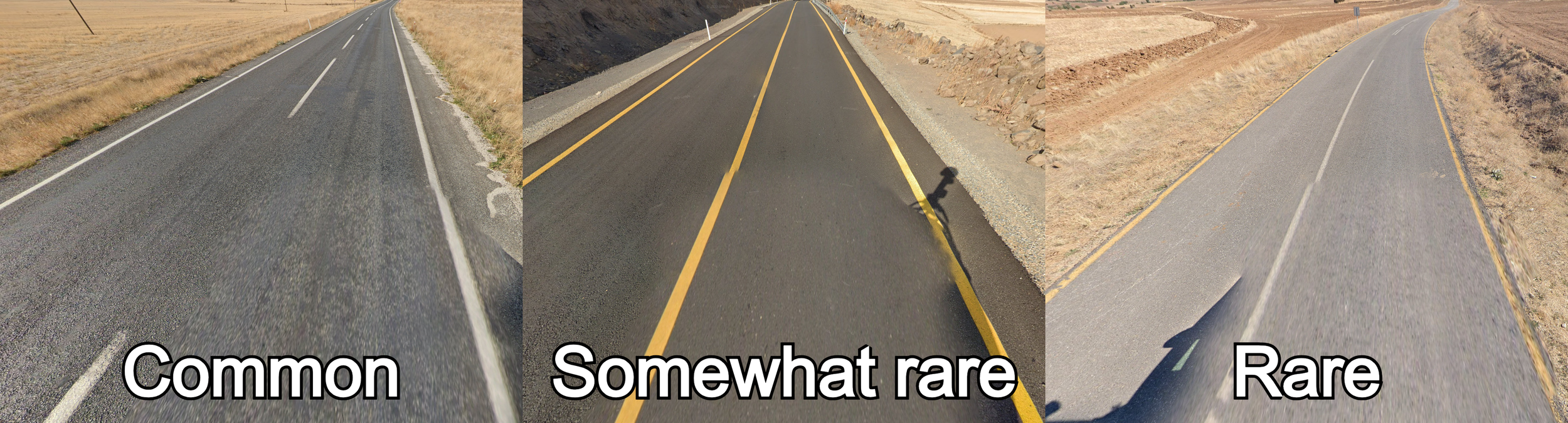
The colour of Turkish road lines is somewhat inconsistent. Most roads simply have white road lines. However, it is not uncommon to see yellow road lines. These roads can have fully yellow lines, or a combination of yellow and white lines.

Many roads have pavement with a grainy “salt and pepper” texture.
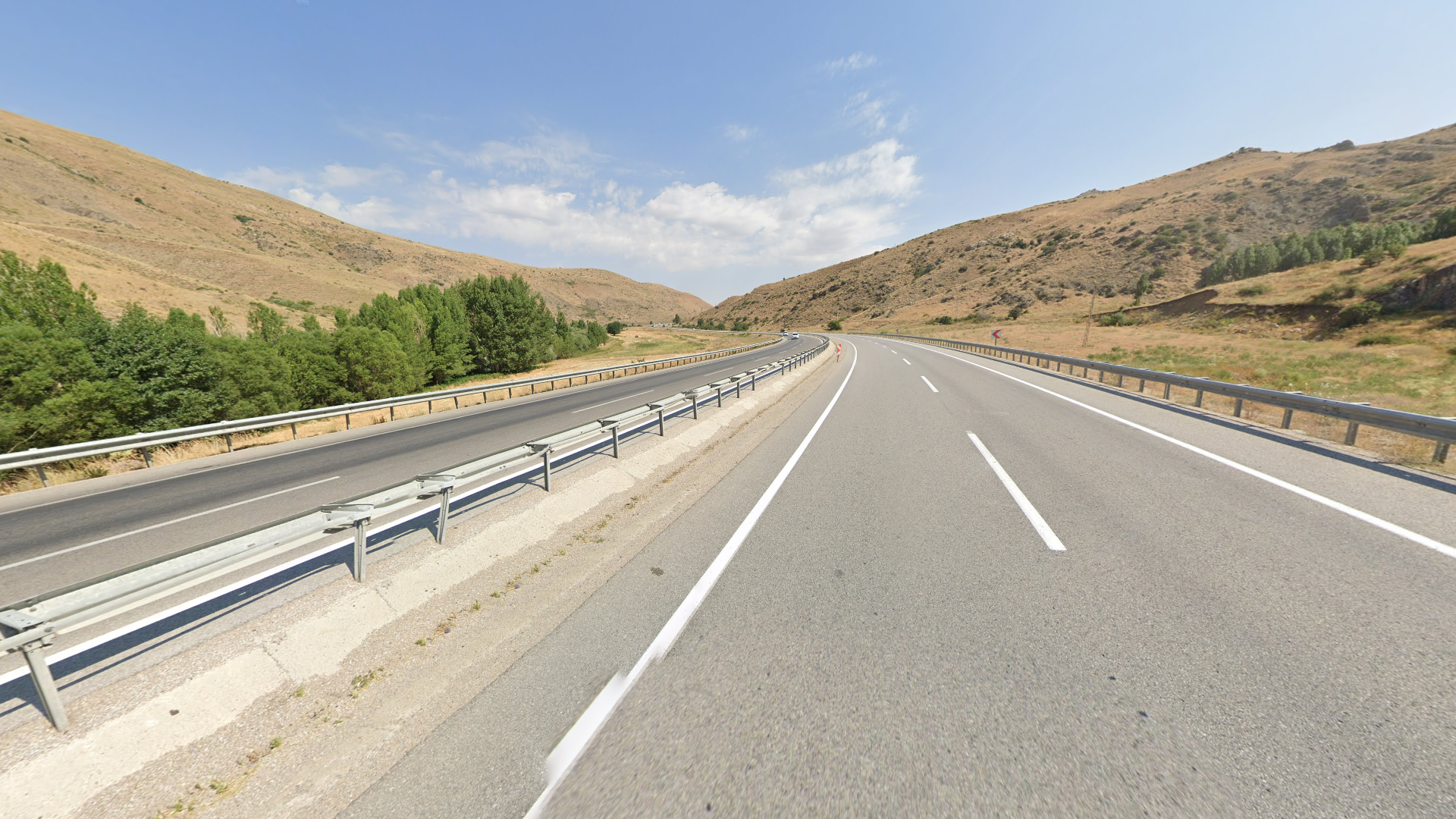
Divided highways are extremely common, especially compared to other Mediterranean countries.
Turkish chevrons are typically red on white. Beware that there are some other regional variants.
Usually, the tip of the arrow does not touch the edge of the chevron. Some chevrons have a neon yellow border.
On intersections, you can often find this distinctive black and yellow chevron, with multiple arrows that point upward.
Sometimes, you can see these narrow chevrons that have a red and white colour scheme.
NOTE: Almost identical chevrons can be found in South Africa.

Direction signs use a very distinct font that can often be recognised by the noticeably wide letter spaces.

Snow poles usually feature a colour sequence of black-orange-black-white from top to bottom, with small red reflectors.
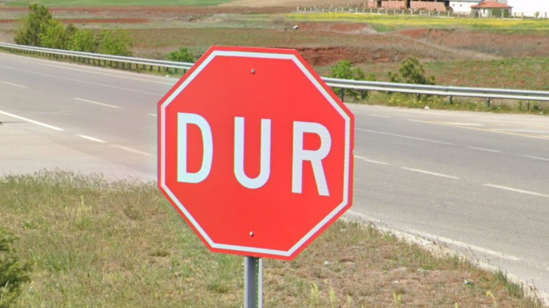
Stop signs have the word “DUR” written on them. This is unique to Turkey.

Turkey uses both main types of guardrails:
A-type guardrails, which have rounded edges.
B-type guardrails, which have square edges.
While most Mediterranean countries use the A-type, B-type can help solve some tough 50-50s. Furthermore, seeing both types will exclude all southern European and Middle Eastern countries, other than Montenegro and Israel & the West Bank. For a full overview of which guardrails are found in which European country, see this infographic.

Metal poles, either in the shape of a ladder or with a mesh pattern, are extremely common in Turkey.

In the Generation 3 coverage, the Google car never has an antenna.
The Generation 4 coverage in Turkey typically features a white Google car. Usually, only a tiny sliver of the back of the car is visible. The car can have a short antenna, or no antenna at all.


Turkey also has Generation 4 “smallcam” coverage, which is mounted lower than regular Generation 4 and has a relatively big circular blur with a small protrusion at the front. The blur can also be fully transparent, making it harder to spot.

The Turkish landscape ranges from arid in the southeast to a Mediterranean landscape in the southwest. In the north you will often find a more forested and lush landscape. The most typical landscape is semi-arid, either rolling or flat, with vast agricultural fields, containing very limited vegetation other than crops.
Beware that Turkey is a very naturally diverse country with many landscapes that are not mentioned in this tip.

Tall and somewhat square apartment blocks are very common in Turkey.

Turkey is a muslim country, and as such mosques can be found in most towns. In particular, tall minarets are extremely common and a good clue for the country.
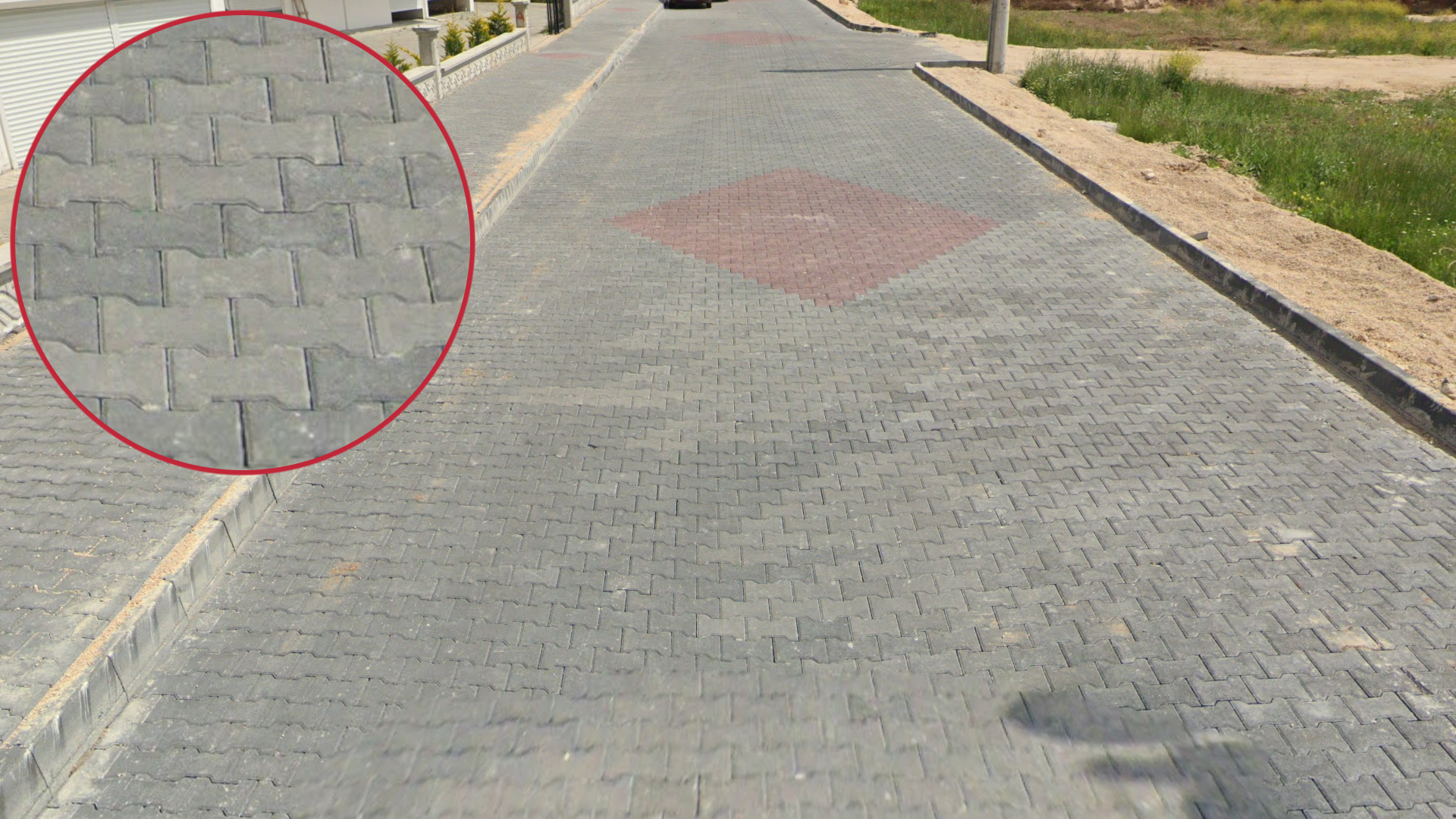
Brick pavement is very common in urban areas, and the bricks will typically have the shape shown in the image.

Turkish area codes follow a fairly easy to learn pattern and can be very useful to get the general region. Most notably, the first digit of area codes are ordered from 2 in the west to 4 in the east.
NOTE: Phone codes starting with 5 are not regional.
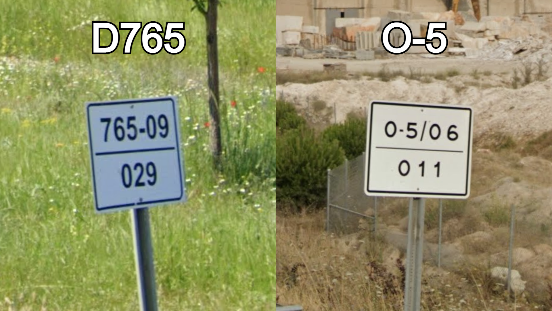
Turkey has three main types of numbered roads. The largest type are the O-roads, which on kilometre markers feature an O followed by a hyphen and the road number. The second largest type are the D-roads, which omit the “D” on kilometre markers and instead only feature a 3-digit road number, followed by the road section number on the top and the kilometre at the bottom. The section number will generally increase to the southeast.

The third type of roads are provincial roads. While these generally aren’t labelled on the map, they can still be used to regionguess since the kilometre markers feature the provincial code as the first two digits on the sign. These codes generally increase alphabetically from 01 to 76 with some newer regions being unordered. Shown in the image is a road from the Afyon Province (03).

Northern Turkey tends to be significantly lusher and more forested than the rest of the country.

In the northeast you will find uncultivated grasslands in valleys surrounded by round hills. Trees are very limited in the region. In Generation 3 the area has an extremely distinct look, with deep green grass covering the hills. It is significantly more difficult to recognise in Generation 4, where the grass has a more arid look.

Turkish pines (pinus brutia) are mainly found near the Mediterranean coast.
NOTE: Turkish pines can appear very similar to Aleppo pines, which are uncommon in Turkey, but are often found in other Mediterranean countries.

Tea plantations are common in the province of Rize.
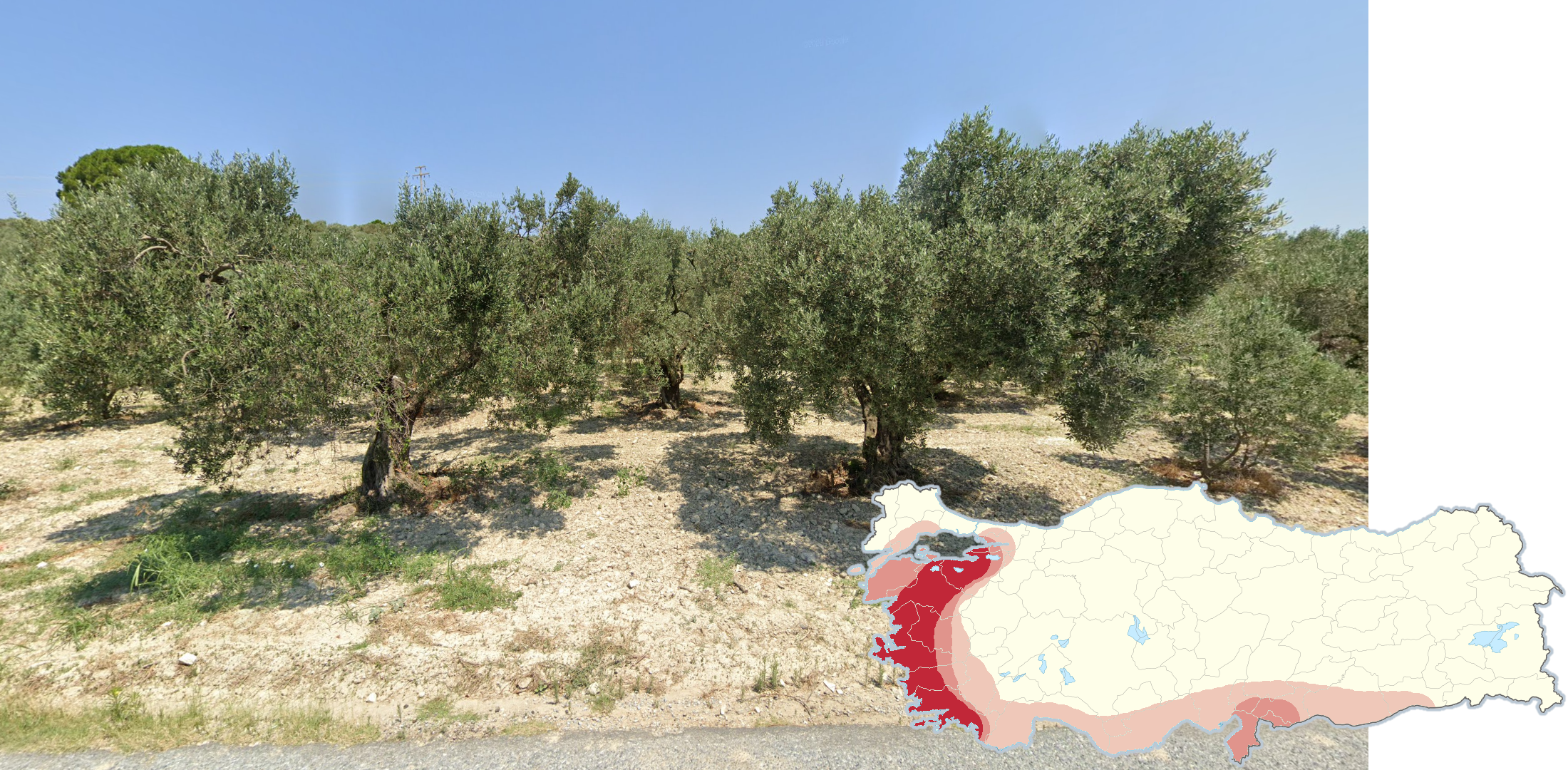
Olive trees are mainly found on the Mediterranean coast.

Sunflowers are mainly found in northwestern Turkey.

A majority of all vineyards in Turkey can be found in a region east of Izmir.

Cotton is mainly found in the region surrounding the city of Şanlıurfa.

Lake Van is by far the biggest lake in Turkey and has a semi-arid landscape, being surrounded by dry grassy hills and occasional trees and agricultural fields near the shore.

Dark, volcanic rocks are commonly found between the cities of Şanlıurfa and Diyarbakır.

River valleys surrounded by steep, barren and rocky cliff sides can be found between the cities of Erzurum and Artvin and in the southeast near the city of Hakkâri.

Tiled roofs are mostly found in the western two thirds of the country.
Note that for this and the following roof-related tips to be reliable, the majority of all visible roofs should preferably be of that type.

Flat roofs are mostly found in the southeast and to a lesser extent along the south coast.

Metal roofs are most common in the east.

Sheet metal roofs shaped like low pyramids are mainly found far east, particularly in the general area surrounding Lake Van.
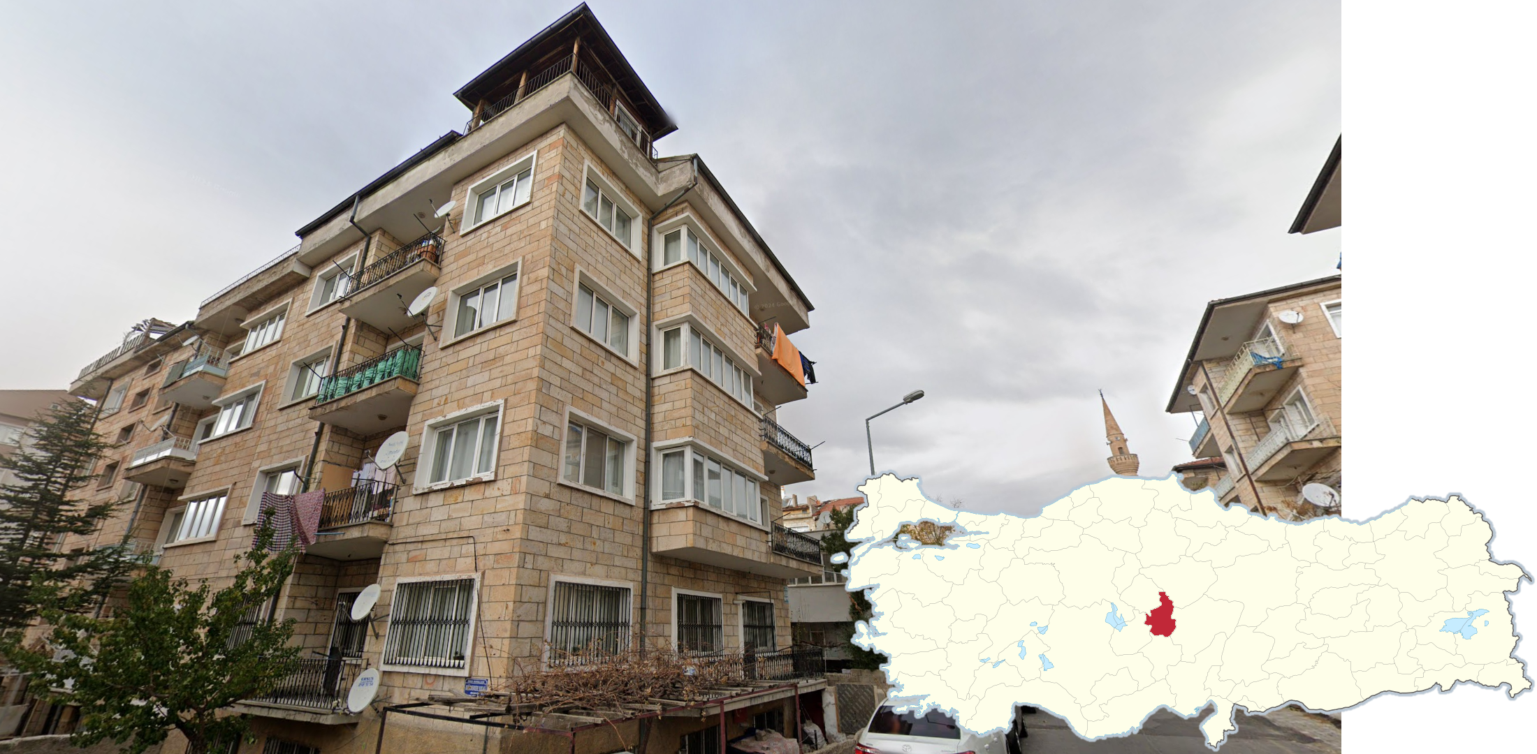
Many buildings in the Nevşehir Province are built by large, light and unevenly coloured, sandstone bricks.
Yellow on black chevrons are mainly found in and around the Balıkesir Province in the west and in the Kars Province in the far east. Beware that you may very rarely find them elsewhere.
Black on yellow chevrons are mainly found north of Izmir.

Four-lane divided highways with no divider, other than double middle road lines, are almost exclusively found in the eastern half of the country.
Beware that divided highways with clear dividers, such as guardrails, can still be found in the east.

Vertical water tanks can be found in most of Turkey, but are notably uncommon along the south and west coast.

Horizontal water tanks placed on top of vertical water tanks are primarily found in a line following the south coast and going up to Elâzığ.

Square water tanks with angled corners are found in the south, approximately from İskenderun to Sanliurfa.

White spherical water tanks can be found in the southeast, mainly south of Batman.

Street signs in the Ankara Province are blue with a small round top. Similar street signs can very rarely be found in Giresun.
Beware that some newer street signs are red.

Street signs in the Izmir Province are dark blue, noticeably bulge outwards and very commonly have the emblem of Izmir in white at the top of the sign.

If you find yourself surrounded by greenhouses, you are likely to be along the south coast west of Adana.

Around the city of Bodrum you will commonly find this type of whitewashed buildings with flat roofs, often combined with blue details or unpainted stone walls.

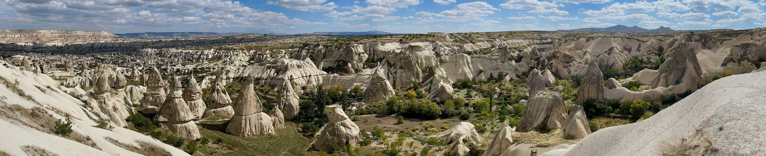
Göreme, west of Kayseri, can be recognised by the tall sandstone monoliths with ancient dwellings carved into them.

Mount Ararat, labelled as Ağrı Dağı on Google Maps, is a dormant volcano in far eastern Turkey and the tallest mountain in the country. It is often seen together with Küçük Ağrı, a smaller volcano to the southeast.

Banana plants are found around the city of Alanya.

Road E99 south of Şanlıurfa is a divided highway which can be recognised by the slightly hazy Generation 4 sunrise coverage combined with the flat agricultural landscape and general south-north road angle.

Road D525 south of Söke is a completely straight road going south-south-west to north-north-east with winter Generation 3 coverage. Along the road you will typically find a large amount of reed.

Along the western shore of Lake Beyşehir and Lake Eğirdir you can find this small single lane road with jagged, exposed rock and Turkish pines to the west. These two can be differentiated by the road west of Lake Eğirdir having a middle road line.

These light blue and grey touristic signs which are either arrow shaped or rectangular with a half circle on the top can be found on the island of Bozcaada.

Red street signs with a coloured bottom strip are found in several cities. In the bottom right corner, you can find a white arrow and some numbers. If this arrow is pointing in both directions and has a single arrowhead, rather than double, then you are almost certainly in Istanbul.
Beware that simple arrows pointing in only one direction can be found in both Istanbul and in other cities. However, if you see such signs in combination with red house numbers, then you should be in Istanbul.

Street signs in Trabzon and Yalvaç are red and oval-shaped. House numbers also feature the same design.

Street signs in Bursa are green, and generally have slightly extruded letters, meaning the signs are not completely flat.
NOTE: Several other types of infrastructure in Bursa, such as fences and guardrails, may also be coloured green.

Street signs in Bolu are also green, but are completely flat and lack any kind of border.
GeoGuessr’s own official maps are not very good, for a variety of reasons. Plonk It recommends the following maps instead:
In addition, here are some resources to help you practise Turkey:
Plonk It Turkey (map link) - This map contains locations for practising each meta in the Plonk It Turkey guide from step 2 to 3.