
Uruguay


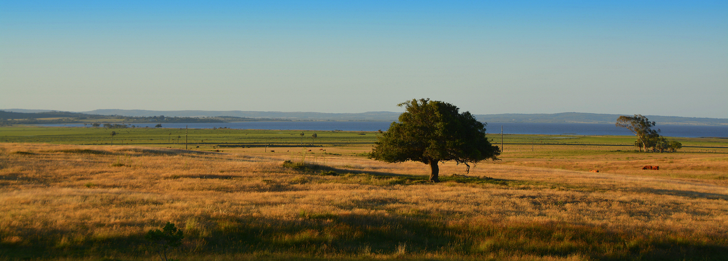
This is the stereotypical Uruguay round. The coverage often, but not always, features overcast weather. Most of the landscape consists of open grasslands with gentle hills. Occasionally, you might see separated tree plantations. Roads are generally in worse condition than in neighbouring countries.

Uruguayan licence plates are plain white with black characters.
NOTE: Neighbouring Argentina also uses white licence plates, but they will have either a black dot in the middle or a blue bar at the top.

Uruguay only has Generation 3 coverage. Coverage was taken by a black Google car without an antenna.
The car is not always visible.
NOTE: Within South America, you can also find this car in Argentina and Peru.

In a lot of coverage, the camera quality is somewhat smudgy.
NOTE: This is significantly less common in Argentina.

Uruguay uses thick wooden signposts, which are typically painted white. They often have up to four rectangular notches at the back of the post.
NOTE: Thick wooden signposts can also be seen in Bolivia.

Uruguay often has these triple road lines, that consist of double yellow roadlines with white dashes in between. This is a design not seen anywhere else in the Americas.

You can also find two other, non-unique road line patterns:
Yellow-white lines (also found in Argentina)
Simple white lines (found in many other places).

These white bollards, with one side often painted yellow, and stone barriers, are specific to Uruguay.

Uruguay uses a handful of different utility poles. One very common and useful one are the so-called trident poles, which get their name from their distinctive pole tops with three insulators that point upwards.
NOTE: Similar trident poles can be found in the neighbouring Brazilian state of Rio Grande do Sul.

You can also see a variety of other pole designs, including:
Round poles with a pole top consisting of flat metal sheets
Square concrete poles.
Both of these pole designs are also good clues for Uruguay.
In addition, you might see simple wooden poles with one insulator, as well as very rarely some Argentina-style poles.
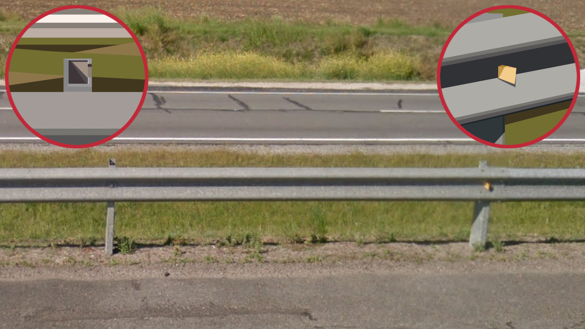
Uruguayan guardrails have a small, rectangular yellow or red reflector, which is the same as in Argentina. They can be differentiated by the shape of their support.
In Argentina, the supports are made up of three sides of a rectangle. Uruguayan supports have the same three sides, and additionally parts of the fourth side at the corners.

This green-painted stone kilometre marker is unique to Uruguay.
Like most of Latin America, chevrons are yellow with black arrows.
NOTE: This is mostly useful to distinguish between Argentina, which uniquely uses chevrons that are white with red arrows.

As mentioned before, most of Uruguay is slightly hilly, even though the overall elevation is fairly low. Although it is by no means a mountainous country, roads generally have at least a slight incline.
Take note that this hilliness is usually very subtle: don’t expect immense rolling hills in most of the country.
NOTE: If your location is completely flat, consider that you might be in Argentina instead.

In many parts of Uruguay, you can find reddish soil. The tint can range from light pink (pictured here) to deep red.
NOTE: This type of reddish soil is less common in the similar-looking parts of Argentina. Hence, it can be a good clue for Uruguay when you are faced with a tough decision.
However, be cautious with using this meta in the inverse way: the absence of this type of soil does not exclude Uruguay, as you can still find a lot of generic white and brown soil throughout the country.

Many Uruguayan houses are made out of concrete, and are somewhat cube-shaped. Walls often have drab colours and tend to look weathered. Flat roofs are relatively common.
NOTE: Architecture in Argentina often looks similar.

Occasionally, you might see palm trees. These short and stocky species of palm tree are particularly common.

Cattle farming is an important part of Uruguay’s agriculture. Cattle outnumber people four by one, so you will see a lot of them around in rural rounds.

Coverage in Uruguay is somewhat limited. The densest coverage is in the south, in and around Montevideo. Outside of this area, most coverage is confined to yellow roads. This makes angle guessing a powerful tool to potentially get very close guesses.
For a zoomable overview of official street view coverage, see this site.

Subtle differences in elevation can help when trying to region-guess Uruguay.
The highest hills are mostly concentrated around two areas:
Near Minas, east of Montevideo.
North of Tacuarembo, in the far north of the country.

The landscape near the town of Minas is recognizable: some of the tallest hills in the country, with lots of exposed rocks, and often heavy bushland vegetation.
The image shown here is a fairly extreme example of this landscape, used for illustration purposes – usually it is more subtle. However, the exposed rock is always a good clue.
NOTE: The landscape in the Quebrada de los Cuervos nature reserve, situated further north, can look similar. In addition, there are also very tall hills in the north of the country. However, these look different (see the tip below).

You can also find tall hills in the north of the country. These can be recognized by their noticeably darker soil. These hills also typically do not have the exposed rocks that are visible in the Minas hills.
The vegetation tends to be natural, and you will often see tree plantations.
This specific landscape tends to be most noticeable very close to the Brazil border, on Route 30 near Tranqueras.

Tree plantations are a defining feature of much of Uruguay’s countryside, but they are especially common in two areas in the north and northwest.
Note that the highest density of plantations is in these areas, but more isolated plantations can be found all over the country.

The region near Lagoa Mirim and the Brazil border in the southeast of the country is noticeably very flat, in contrast to the slight hills found in most of the rest of the country.

There are only a couple of divided highways in Uruguay, all of which are close to Montevideo:
Ruta 1 going west out of Montevideo, up until Colonia Valdense.
Ruta IB going east out of Montevideo, up until Punta del Este.
A short section of Ruta 5 going north out of Montevideo, up until Canelones.
The only exceptions to this are some divided avenues in urban areas, which should be easy to distinguish from actual highways.

These bins with orange lids are specific to Rocha Department. However, you can still find these black bins in both the Rocha and Canelones Department.

Montevideo is by far the largest city in Uruguay. More than half the Uruguayan population lives within its metropolitan area.
Its relatively massive size may not always be as apparent in its suburbs. However, if you are in a densely populated, highly built-up area, consider guessing in downtown Montevideo, as there are very few places like that in other parts of Uruguay.

Punta del Este is a seaside resort town with a recognizable look. It is an affluent and touristic place with a developed downtown that consists of many tall, modern apartment buildings. Its main attraction is its large, sandy beach.
Further away from the downtown area, you will see less highrises, but still a lot of expensive-looking villa neighbourhoods. Here, you will often see distinctive tall pine trees.

The small island of Isla de Flores is located off the coast of Montevideo. It has a trekker where you can see abandoned buildings, and usually also the lighthouse.

This unique Google car is found in the coastal town of Cabo Polonio. It can be recognized by the orange strap on the left.
The coverage is an off-road trekker line on the map. The town that it drives through has a unique vibe, consisting of makeshift-looking shacks, scattered around the seaside landscape. In some of the coverage, the car drives on the beach.

This unique Google car is found in the Valle del Lunarejo natural park, located west of the town of Tranqueras. The car has a white front and a curved black backside with a brown strap.
The coverage is an off-road trekker line on the map. The car drives on a small track through a grassy landscape.
NOTE: This park only shows up as a point of interest on the map, instead of the usual dark green polygon used for natural parks.