

Beginner’s Guide to Geoguessr
What to look for in-game
In order to make an educated guess, experienced Geoguessr players will look for specific clues and consider a variety of different factors. In this section we will explain the most common types of clues you should try to look for when you load into a round of Geoguessr.
A single type of clue will not work for every country, as some countries can be easily recognized by a very specific clue that only applies to it, while others require using a combination of many of the clues detailed below. At first we recommend focusing on the clues that you will see in most rounds, and steadily incorporating more obscure clues into your arsenal.
To learn more about the specific applications of the different types of clues, you may look at each respective country’s Plonk It Guide.
Due to the length of this page, here are shortcuts to the main sections in which it is divided.
General clues
Sun direction
One of the most basic clues present in most rounds of Geoguessr is the direction of the Sun. When the Sun is clearly towards the south, you will be in the Northern Hemisphere, and when the Sun is clearly north, you will be in the Southern Hemisphere. Experienced players will not usually look at the Sun in most rounds, but it is still a very important clue on hard rounds.

It is important to keep in mind that between the Tropics of Cancer and Capricorn the Sun may appear north in the Northern Hemisphere and vice versa during the summer months. You should only trust it completely when the direction of the sun is closer to north or south than it is to east or west.
Driving side
As the vast majority of rounds in Geoguessr are on roads, the side of the road which cars drive on can be a very fast way to exclude a good number of countries.

Only a few countries present in the game drive on the left side of the road. Countries marked green only have very limited trekker or tripod coverage, so driving side is rarely a relevant clue. You can click on this image to enlarge it.
When there are no other cars nearby, you can still tell the driving side in a couple of ways. Traffic signs will be set up on the same side as the cars drive, some parts of the Google car might be visible, such as the antenna in the back of the car, and on dirt roads you will sometimes see a trail of dust behind the car. The driving wheel will almost always be on the side that is closer to the centre of the road, on the left for right hand side driving and vice versa. One of the few exceptions to this rule is cars imported from Japan in eastern Russia.
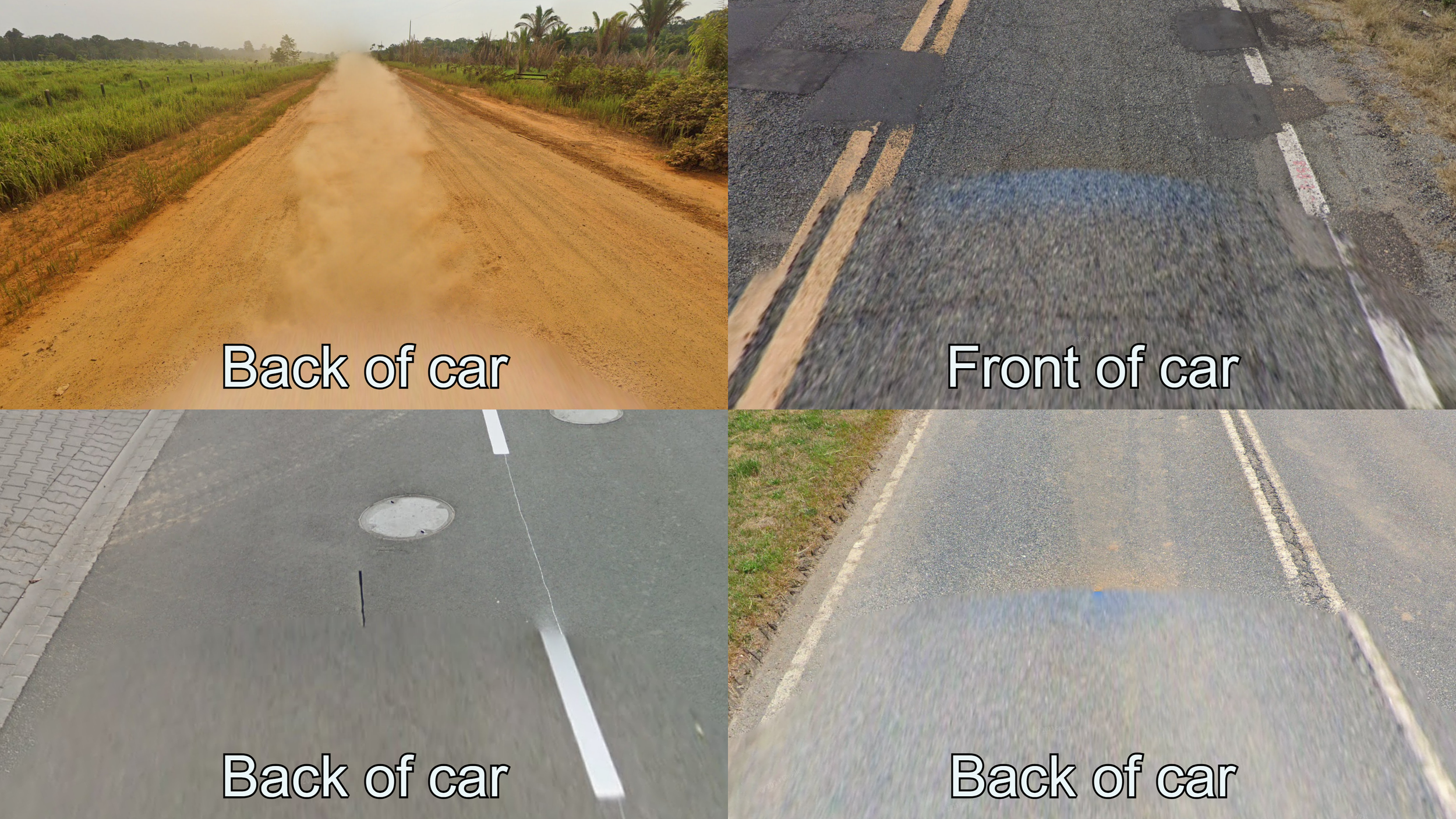
Some common ways you can deduce the driving side. In Gen 4 coverage the difference between the front of the car and the back is very subtle, and you will usually only see one of them.
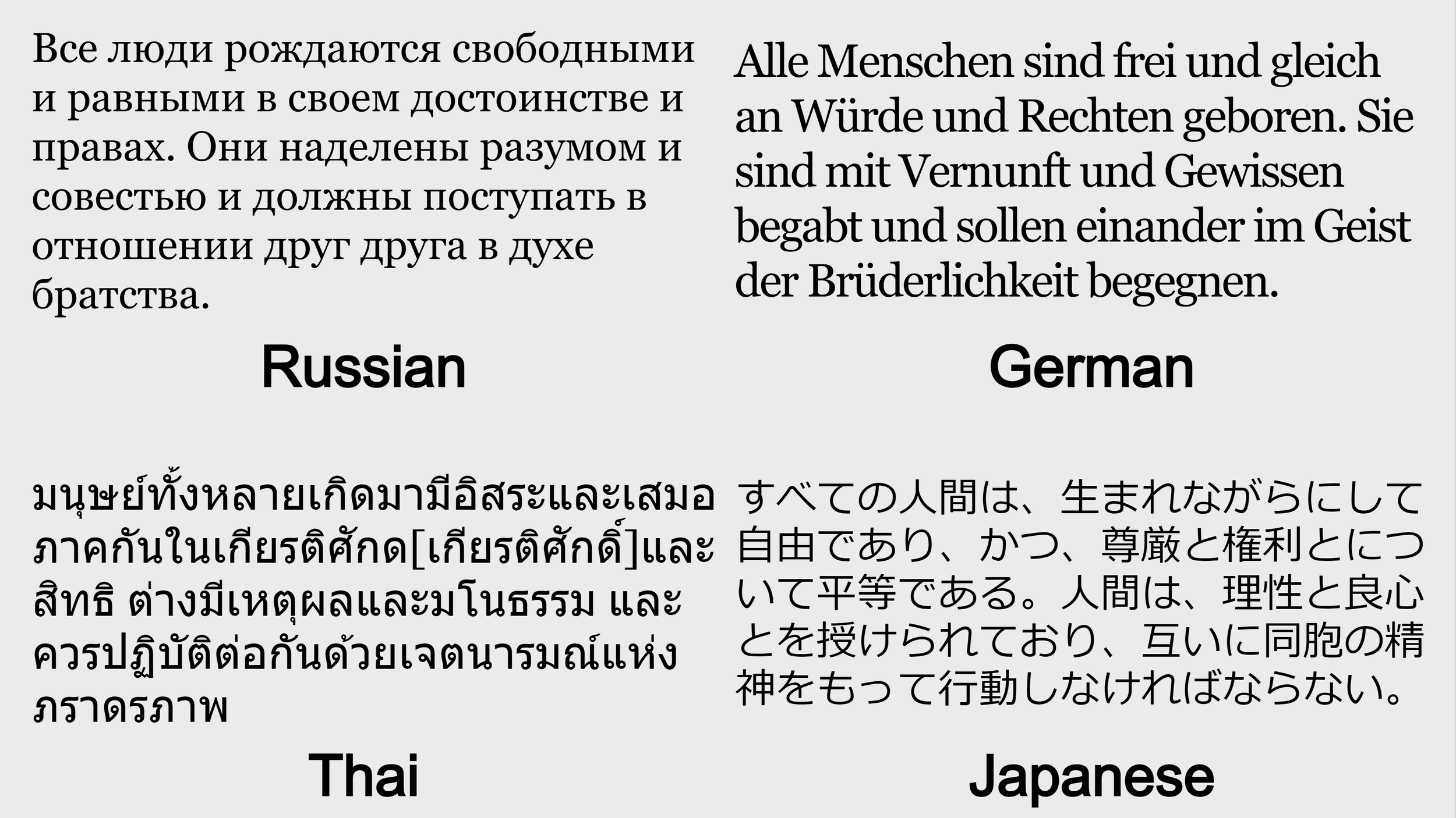
Language
Language is one of the most common clues you will find in urban rounds. Most countries present in Geoguessr use the Latin script, and therefore you need to learn special characters or diacritics, as well as develop a feel for how each language looks, to be able to tell which language you are looking at. However, several countries, especially in Asia, have unique scripts that can easily give you the country in a round.
It is worth mentioning that languages and scripts can also be used to regionguess. For example, India has 23 official languages, many of which are written in different scripts and spoken in different regions. Comparing the symbols from the text you see in the round to the place names you see in the map can be an effective tool to regionguess India at a basic level. Some countries do not have its own language, like Switzerland, which has French, German and Italian speaking regions. In other countries, like Spain, there are regional languages unique to their own regions.
Flags and domains
One of the most intuitive clues new players use are country flags and internet domains. While knowing the flag and domain of every country found on Street View is a basic skill for a Geoguessr player, we do not recommend relying on it too much as a new player. The gameplay loop of moving until you find a flag, url, etc. and guessing in the middle of that country does not promote learning and hinders the experience.
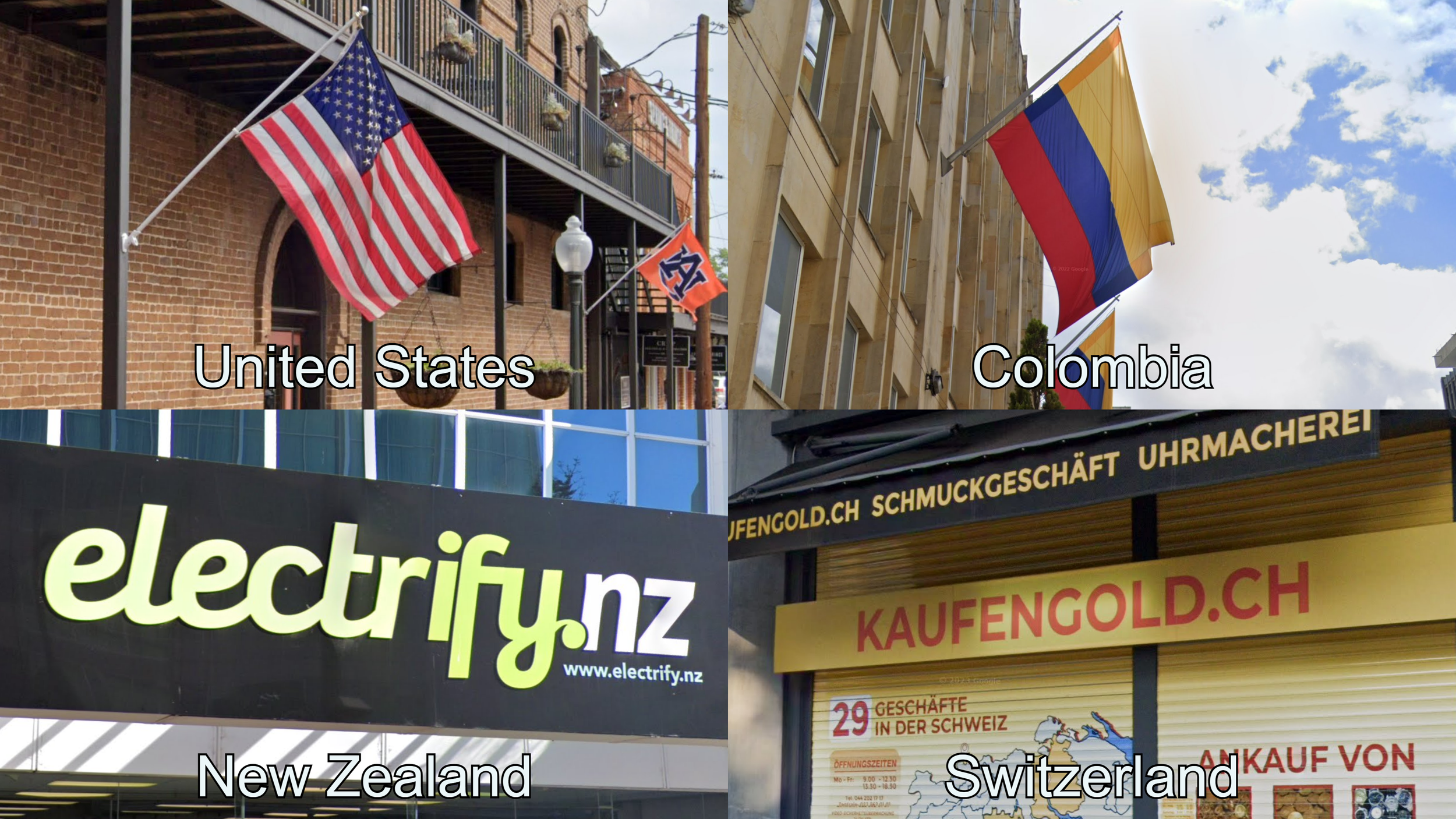
Some flags can be confused with each other, for example Malaysia uses a similar flag to the US and Ecuador’s flag has the exact same colour pattern as Colombia. While some domains are very intuitive, such as .nz (or .co.nz) for New Zealand, others can be deceiving. For example, the domain for Switzerland is .ch (standing for “Confoederatio Helvetica”, the country’s official name in Latin).
Architecture
Architecture will almost always be a good clue in any urban or semi-urban round. Building styles, techniques, and materials can vary wildly throughout the world, and even within a medium-sized country. Whenever you can see any sort of building, it is always worth looking at and try to think of which countries it fits best in.
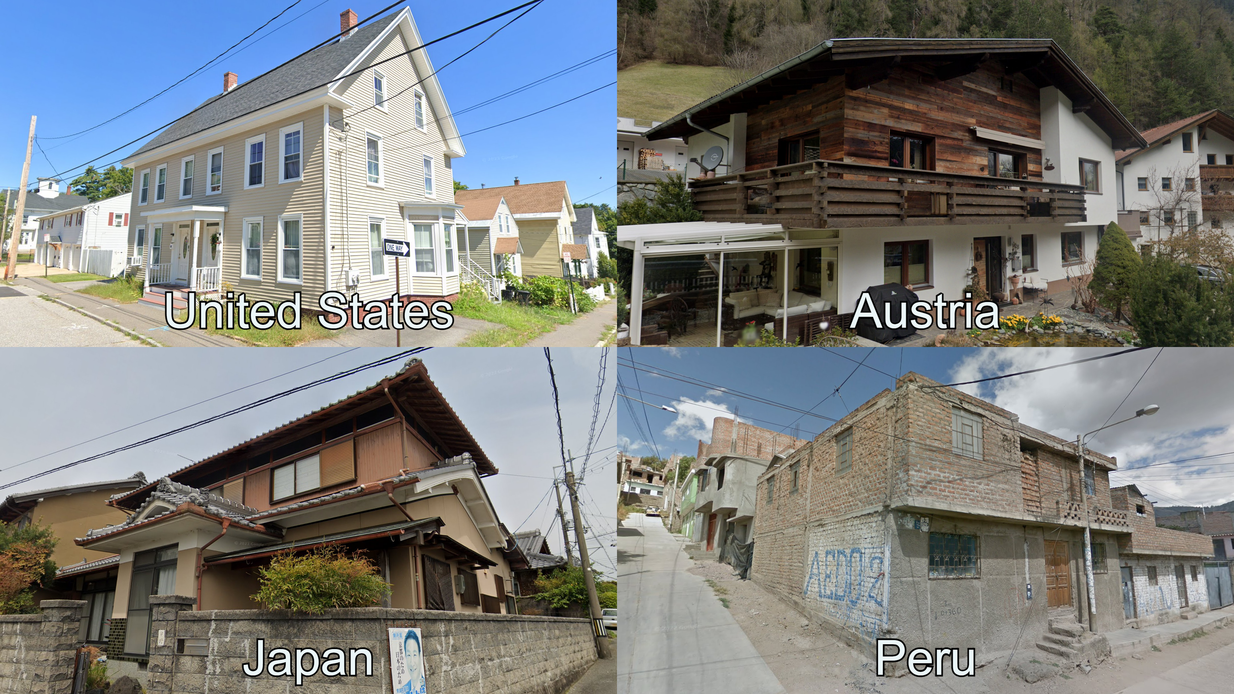
Houses in eastern US and Canada are often one or two storey wooden buildings. Alpine architecture usually features big white houses with dark wooden details. Elaborated roofs with wooden supports are characteristic of Japanese architecture. Some areas in Peru and Bolivia have almost exclusively flat roofed houses with exposed red bricks.
It is important to keep in mind that architecture tips can be inconsistent, people can build houses in the style of another country for a variety of reasons, and new development can look nothing like traditional architecture of the country. Nonetheless, it is a very good clue to learn.
The key clue to recognize some countries or regions can be any sort of detail about the architecture. Roofs are a very common clue used by Geoguessr players in some countries as they can usually be seen from afar.

Within Indonesia, tiled roofs with patchy colours are a good clue for the island of Java. The vast majority of buildings in Luxembourg have a black tiled roof. Nigerian houses often have a big metallic roof. Houses in Bulgaria are infamous for their poorly made tiled roofs.
Sometimes, very specific regions of the world have unique buildings or architectural techniques that can get you extremely close guesses if you know them.

In a small part of Apulia, Italy, you can find cone-shaped stone roofs on buildings called Trullo. In Dalarna, Sweden, you can find highly decorated chimneys reminiscent of crowns. Traditional houses called Tongkonan are only found in a small part of South Sulawesi, Indonesia. They are typically built on stilts and feature big boat-shaped roofs. In the Northern region of Asturias, Spain, granaries built on pillars called Horreos are very common.
Landscape
The landscape around you is naturally one of the most basic clues to use in a Geoguessr round. It is completely normal for new players to feel like forests and mountains around the world are impossible to distinguish from each other, however, with a little bit of practice and reading guides, anyone can overcome this initial stage and learn how to confidently tell apart different countries just by their landscapes.
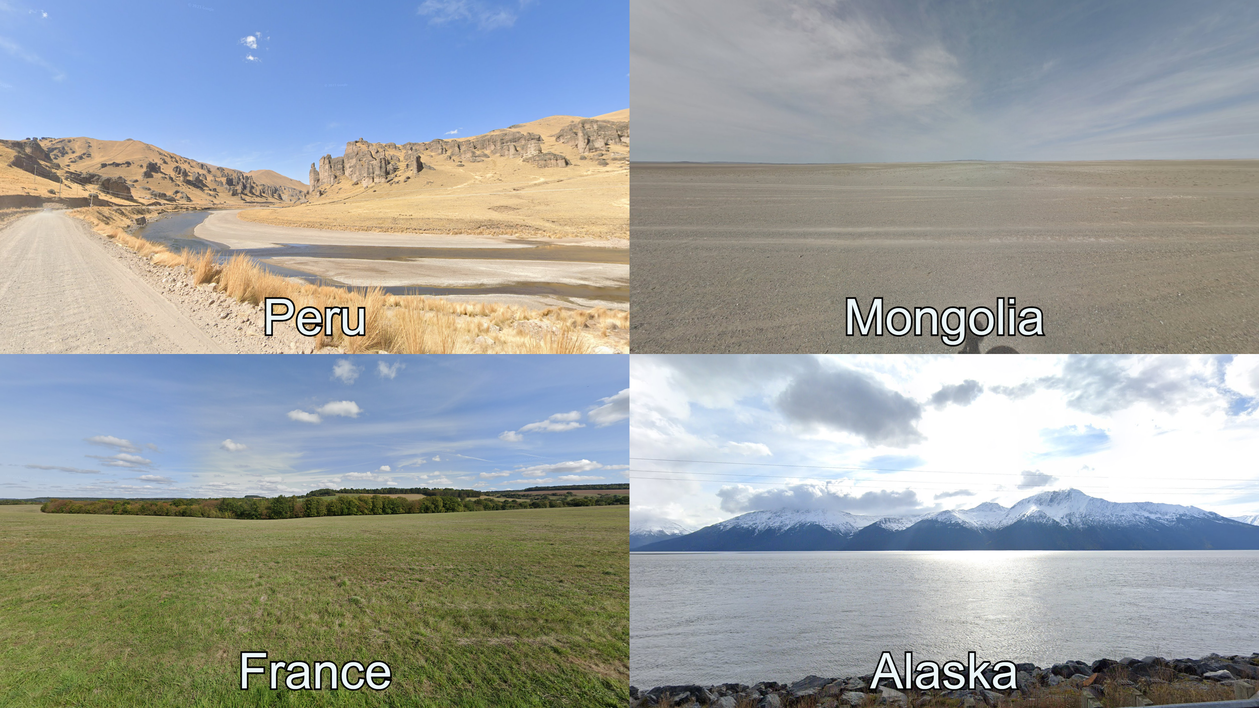
The Peruvian part of the Altiplano usually features a semi-arid look with only low vegetation. The Gobi Desert in Mongolia is one of the most arid places with coverage in Street View. Temperate forests and farmland cover most of Western and Central Europe. In Alaska snowy mountains and fjords are very common.
Sometimes, Geoguessr players will say that a round without any concrete clues “just looks like…”. Getting a feel for how a country or region usually looks requires experience, either playing the game or clicking around in Google Maps (usually called coverage checking). However, a landscape can be broken down into small pieces that you can look for instead of just getting a general view of the round. In the following sections we will try to describe some of the things that are commonly used to go from “this is just a road with trees around” to an educated regionguess confidently in one country.
Vegetation and crops
In rural rounds, there will almost always be trees and plants around the road. These can be both wild and planted by humans, but will very often be useful to extract information as to where a round could be. From the basic distinction of temperate forest to rainforest, to learning the range and key identifying characteristic of specific species, botanical knowledge is a very strong tool that Geoguessr players slowly build.
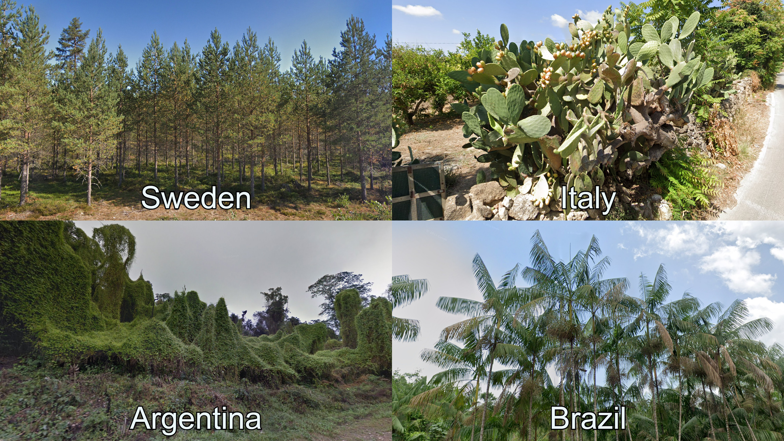
Baltic pine forests can be commonly found in most of Northern and Central Europe. Prickly pear cacti can be found in the driest parts of Mediterranean Europe. An invasive species of Ivy covers most trees of the RP18 in Salta, Argentina. This road is famous in the community due to its usage as a bait location in many maps. Açai palms can be used to regionguess the state of Pará, in Brazil, but can be found throughout the Amazon rainforest.
Crops can also be a useful piece of information for a Geoguessr player. Since most countries have a government branch regulating and keeping track of agriculture, research into this topic for advanced regionguessing is very common. However, agriculture can still be used on a basic level to have an idea of the continent.
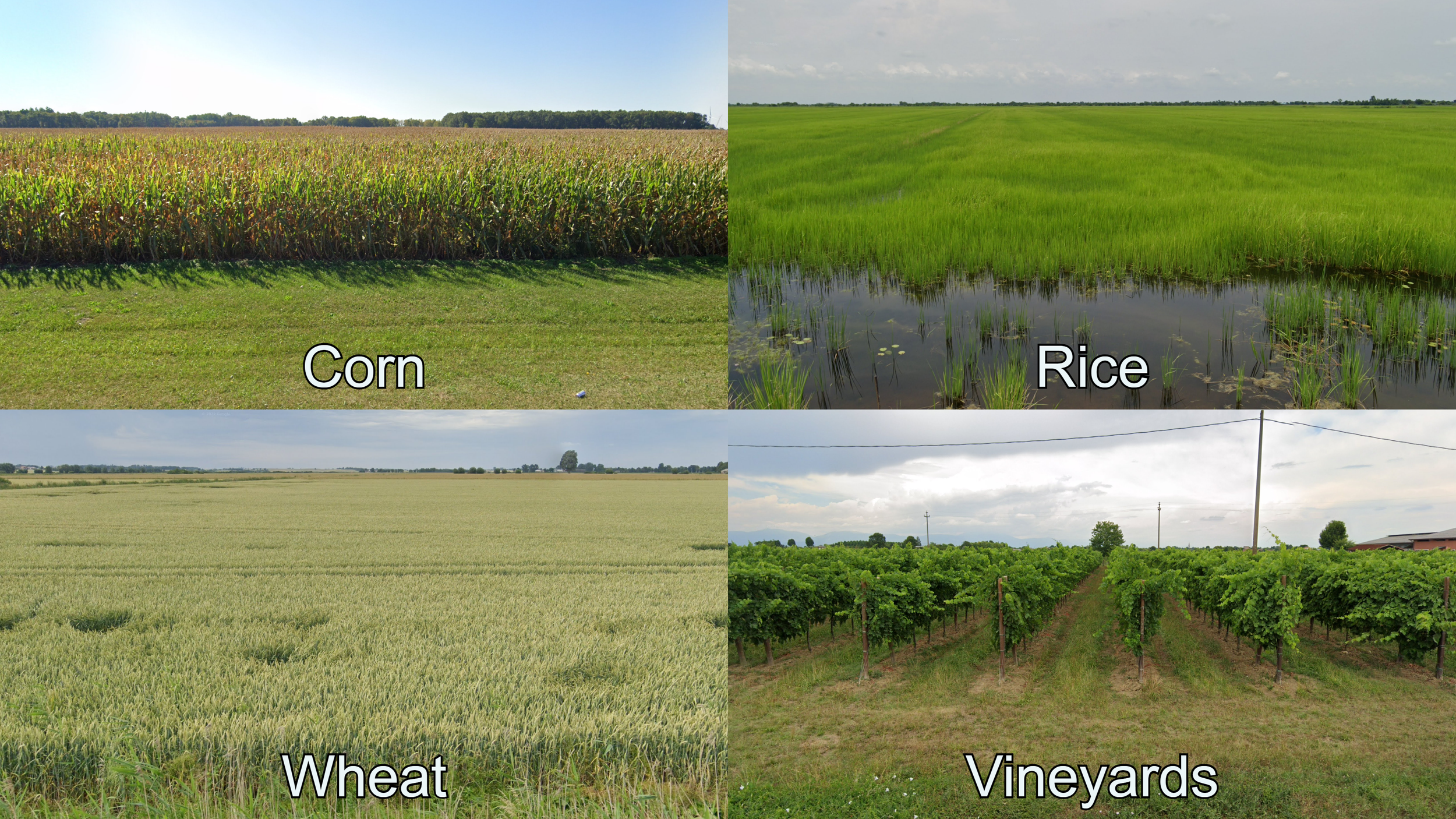
Corn and cereals like wheat are the most common crops in North America and Europe. Rice is extremely common to see in the agricultural areas of Asia. Wine is usually produced in specific regions, such as the Veneto region in Italy.
Geological features
The colour of the soil, especially in countries with many dirt roads, can be a very useful tool. Some countries and regions are known to have very red looking soil. Similarly, others can have extremely bright and/or sandy soil. This is something that usually requires experience and playing, since distinct soils have a certain look that, while easy to recognize, is very hard to describe.

Brazil is known for having some of the reddest soil in the world. Very dark soil is common in places with volcanic activity, such as Iceland. Some players claim “Russian dirt” looks unique. The Yucatan Peninsula in Mexico has extremely bright and sandy soil.
Last but not least, the topography of a country is a fundamental clue for getting a round right. While learning which countries have the biggest mountains or where you can find very flat areas is easy, you need to pay attention to the features that makes the landscape of a certain country unique in order to use it as a source of information in your games.
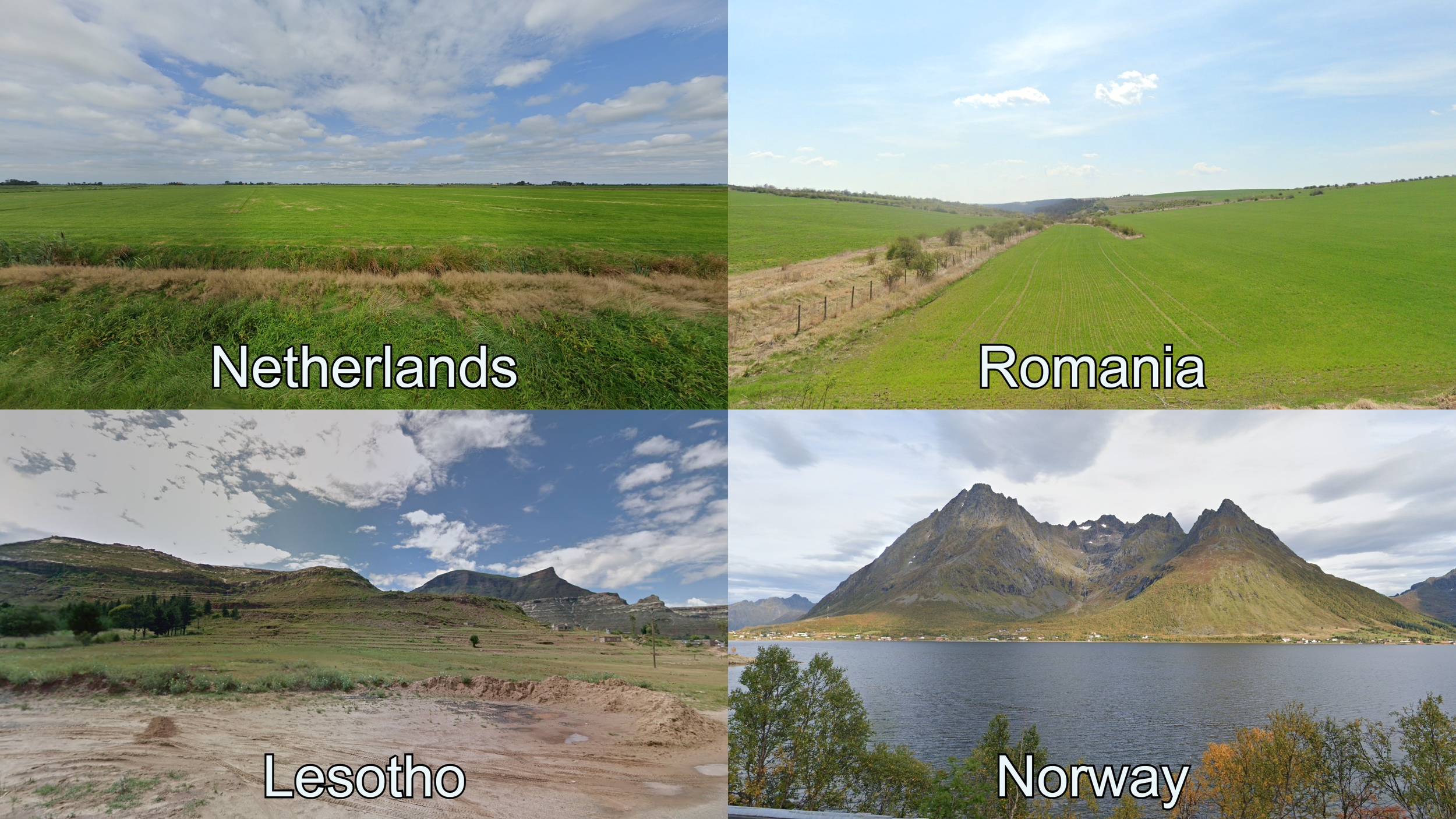
Netherlands is typically an extremely flat country. Eastern Romania has a rolling, agricultural landscape. The unique erosion pattern of the mountains in Lesotho can be recognized by the horizontal layers of exposed rock and the many table top mountains. The mountains of Lofoten in Norway are the spikiest in the country, featuring a particularly jagged look.
Checking the terrain map of different countries, while practising or after rounds, and correlating that information with the elevation changes you see in the round, is a very good way to learn the topography of different countries.
Infrastructure
Due to the nature of Google Street View, most rounds of Geoguessr will be on roads. Therefore, the most consistently useful clues are things that appear on, or next to, roads.
The material of the road, colour of the roadlines, bollards and roadside utility poles are extremely common items used by Geoguessr players to know what country a round is in, or even guess the right region of a country.
Bollards
Bollards are small safety markers typically placed next to the road. Roadside bollards and other markers like snow poles are a very good clue to determine the country, as most countries that use them have a unique design. Trying to remember the most distinct bollards you see in your games is a very good first step towards consistently recognizing the country.

Mexican and Icelandic bollards are completely unique to their respective countries. You can also find the French bollard design in Senegal, and the Italian design in Albania and San Marino.
A very important detail about bollards, particularly in Europe, is the shape and colour of the reflectors. Superficially similar bollards can often be distinguished by their reflectors. For example, Spain and Germany both have white, wedge-shaped bollards with a long rectangular reflector in the front and two circular reflectors in the back. The key difference is that the front reflector is yellow in Spain.
Roadlines and material
As most locations on Street View are on paved roads, the colour and shape of the roadlines, as well as the material and quality of the road, are extremely consistent clues to narrow down a location to only a few countries. Roadlines on their own will rarely define a country, but combined with other clues they become one of the most reliable things to use in your games.

Norway is the only country in Northern Europe with long outside dashes. Double yellow middle lines are very common in the Americas, and the most common roadline in the US. Outside yellow lines are a very good clue for the countries in the south of Africa and the Middle East. Zig Zag style lines in urban areas are very common in the United Kingdom.
The quality and material of a road can also be a way to guess a location. It is not as consistently useful, but it can be a very strong clue for a few countries and regions. For example, only a handful countries use concrete roads commonly, and poorly maintained roads are significantly more common in some countries than others.

Almost every paved road in Philippines is composed of concrete slabs. Roads in Ukraine are frequently very damaged, with many patches of new asphalt covering potholes. Roads made out of small bricks in the pattern pictured are characteristic of Dutch residential areas. Roads with a strong red tint are very common in Dalarna County in Sweden.
Traffic and directional signs
Traffic signs can have many distinct features that players use to recognize the country. Some clues may be obvious, like the stop signs pictured below, while others are more subtle, like the thickness of the red border in a traffic sign or the font used in a speed limit sign.
Other road related signs, such as kilometre/mile markers can also be unique to a country or group of countries.
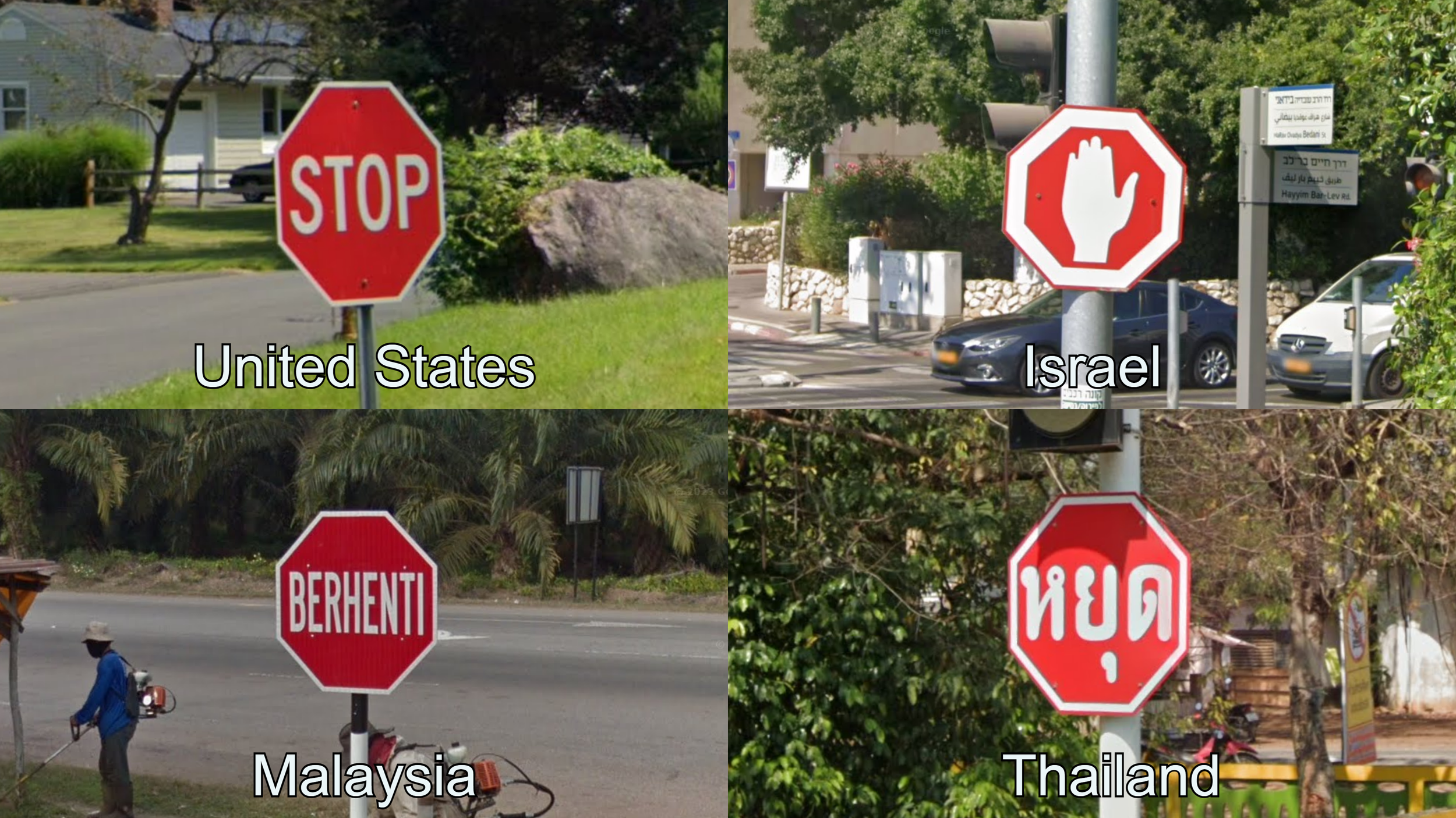
Israel, Malaysia and Thailand have unique Stop signs.
While most of the time you see a directional sign you can use the placename to deduce what country you are in, knowing the designs used by different countries can also be a strong clue when you are playing No Move or NMPZ.

Austria and Slovenia can be very hard to tell apart in some rounds, but Slovenia uses yellow directional signs, while Austrian ones are white. Estonian and Finnish are closely related languages, and placenames can look very similar. You can recognize their directional signs by the arrow. Estonia has a small arrow drawn in the sign, while Finland incorporates it into the white border.
Street Signs
Street signs can be a very useful clue in urban rounds. They, of course, are very helpful towards pinpointing a round, but they can also be used to know the country or the city in formats that do not require you to 5k. For example, many languages have unique words for “street”. Also, some big cities have very distinct street signs that players have learnt to recognize.

Ankara has blue street signs with an arched top. In Bucharest, street signs have a similar shape but with a characteristic green outline. The entire country of Singapore uses green street signs with white text in a distinct font. The city of Budapest uses white rectangular street signs with black text written in serif font. The district is written in the top row in Roman numerals.
Utility poles
Utility lines can be found next to roads in both urban and rural locations, and are therefore an extremely powerful tool to have in your arsenal. The material of the pole (wooden, concrete, metallic, etc.), the shape of the pole, or the poletop sustaining the wires, as well as various markings on the pole can all be determining factors to know where a location is.

A double pole made of concrete as pictured is very common in Argentina. A wooden pole with a metallic frame, often holding five electricity lines, is a good clue for Greece. A diamond-shaped poletop holding three electricity lines underneath is known as a “French poletop” in the community, but can also be found in other countries like Spain and Senegal. A concrete pole with five thin and long holes is typical for Romania.
Vehicle registration plates
Cars and other vehicles will almost always have some sort of registration plate. The colour, shape, presence or lack of a front plate, or any particularly colourful markings can be used to recognize some countries.

Colombia is the only country in Latin America with yellow plates on private vehicles. Italian front plates are shorter than most European plates, and have a blue stripe on both ends. On most Ukranian plates you will be able to see the country’s flag on the left side. Each state in the US has unique license plates. Some, like Vermont, are very recognizable.
Coverage clues
Using Google Street View as the base for the game means that the locations found in game will always contain information relating to when and how that imagery was taken. The tips listed in this section are the hardest to grasp, as they are not things you would find if you were to travel to the country itself. Some players like to stay away from these types of clues as much as possible, but the reality is that some of them are extremely useful.
We recommend playing in a way that you enjoy, however, there are many countries and regions for which the easier way of recognizing then is to use coverage clues, and are therefore found in Plonk It guides.
Camera Generation
Google has mainly released footage with 4 different types of cameras that produce a distinct image quality, these are known as camera generations within the community (usually shortened to Gen 1/2/3/4).

Generation 1 coverage has extremely low resolution and is not used in most community maps due to its low quality. You should not find this in your games.
Generation 2 coverage can be easily distinguished by the wide circular blurs at both the bottom of the image (covering the car) and in the sky. Its resolution is still somewhat low and reading signs is often difficult.
Generation 3 coverage has much better resolution than Gen 2, but the colours are generally rather unsaturated, making for dull-looking images. The sky will often look greyish even on sunny days.
Generation 4 is the latest and highest quality available. It has the best resolution and vibrant colours, frequently resulting in slightly oversaturated images.
There is also another camera used by Google, it is a low cost camera operated only in a few countries. It is known by the community as “shitcam“ due to its low quality. Despite this, “shitcam“ coverage keeps being released as of 2024. This camera can be identified by its low resolution and the wide circular blur covering the car.
You can click on this image to enlarge it
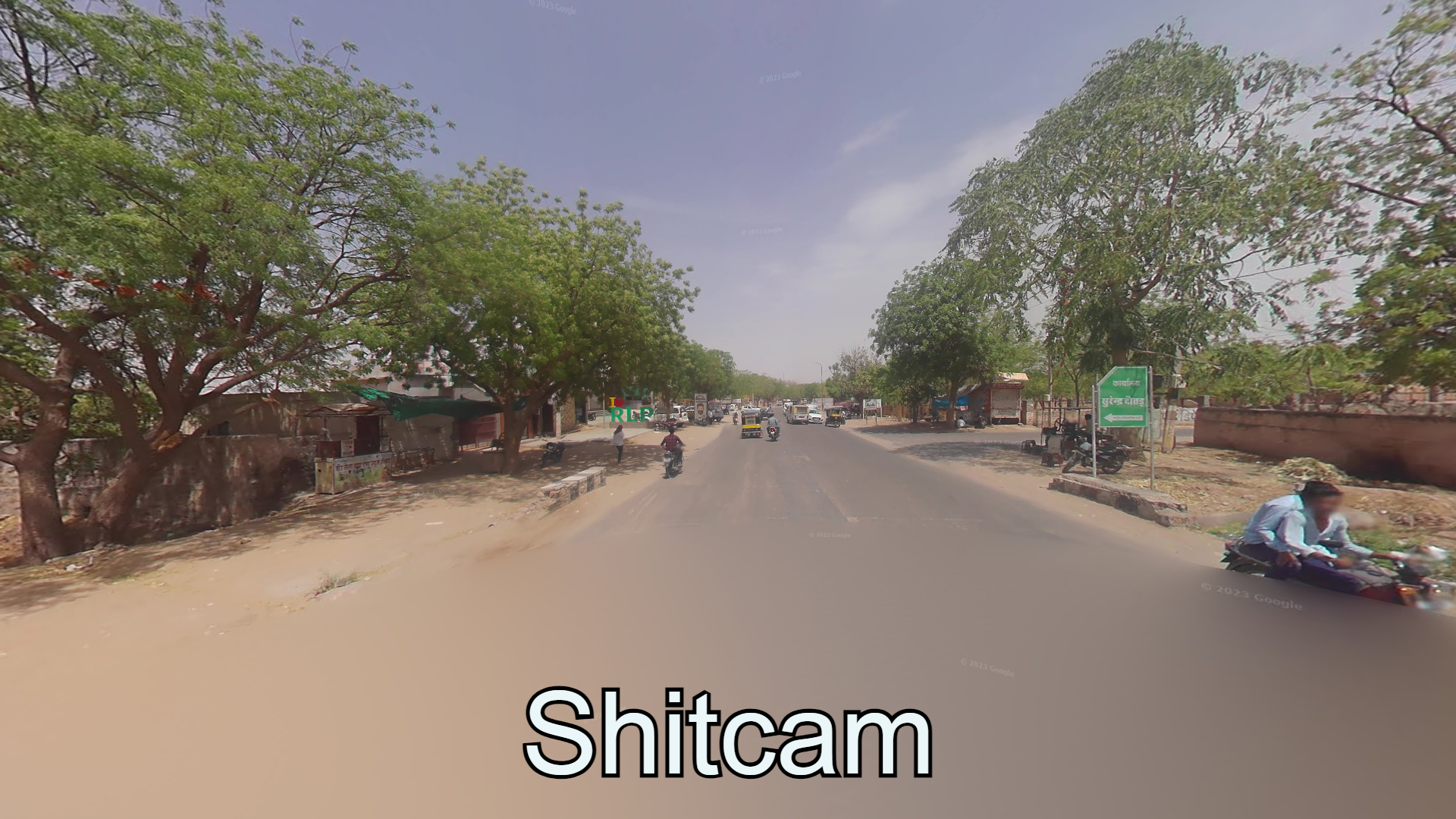
This camera is the main camera used in India, and can also commonly be found in countries like Nigeria, Cambodia, Lebanon and Ecuador. In the summer of 2025 Google also released coverage taken with this type of camera all over Europe. While it will very rare to encounter it as mappers prefer higher quality footage, it is important to know it exists.
Knowing the generations of camera that exist in each country can be a very powerful tool to narrow down the list of possible countries, but we only recommend learning this as an intermediate player.
Lowcam
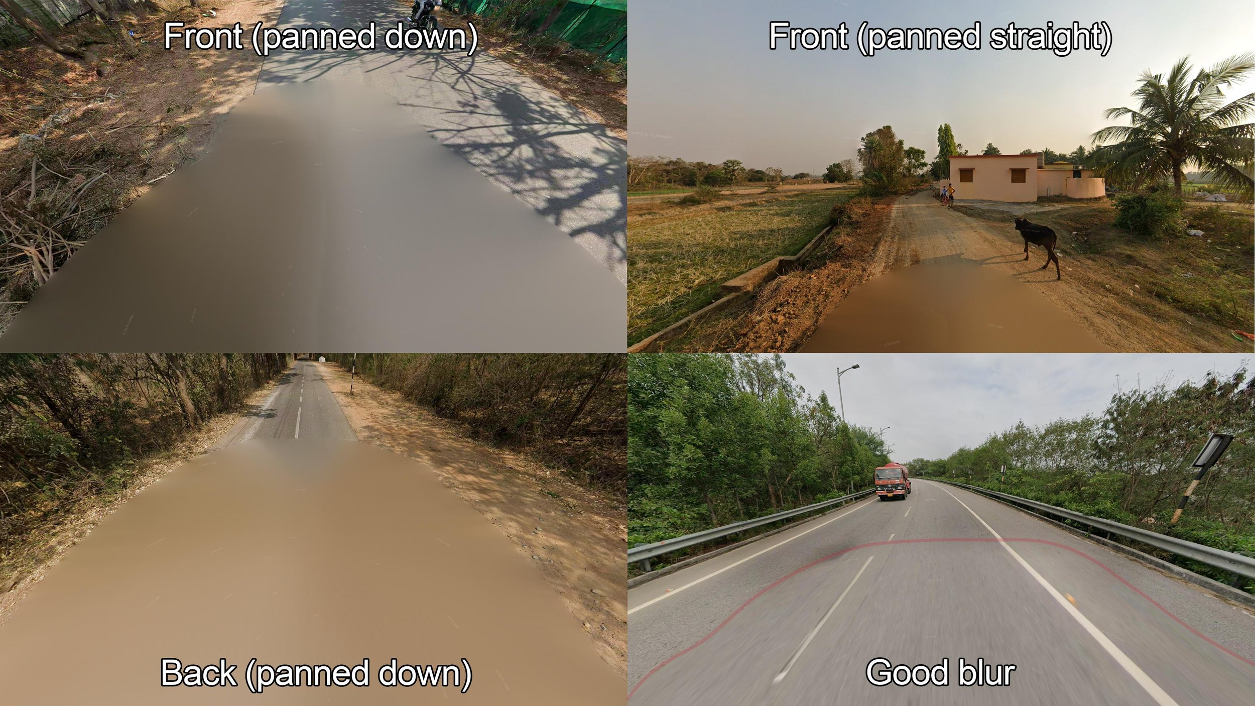
In some countries, due to privacy concerns, the camera is mounted lower on the car, giving it a lower vantage point that can be easily recognized. This means that items around the ground will appear taller, and the blur on the Google car will be bigger than usual. The countries that use this camera exclusively are Liechtenstein, Switzerland and Japan. Sri Lanka uses this camera mounting in Generation 4 coverage.

An example location of lowcam in Switzerland, notice how the corn is almost higher than the camera, compared to the view from above you would see in countries with regular camera like Spain.
Sometimes people mistake the big circular blur from Generation 2 coverage with lowcam, to avoid this mistake you should try to confirm that you have indeed a lower vantage point than usual. Generation 2 coverage also has a circular top blur that you will not find in lowcam. Another common way to mistake lowcam for regular camera and vice versa is when the round is on a road with a high incline. Normal camera can look like lowcam looking uphill and lowcam can pass for normal camera when looking downhill.
Lastly, countries that use a big truck for their coverage have technically a lower camera mounting than usual, but they can be easily distinguished by the Google car (this topic will be discussed later on in this section) and that coverage is not referred to as lowcam by the community.
Smallcam
In late 2024 Google released the first images taken using a newer smaller camera, commonly referred by the community as “smallcam”. This camera has virtually the same image quality as the Generation 4 camera. It can be recognized by its circular blur, with a small protrusion at the front, resembling the shape of a ladybug or a water canteen. It is also mounted lower on the car than the standard Generation 4 camera.
Smallcam blur is usually solid, but you can also find a less jarring version that blends nicely with the road.
In some countries some parts of the car may be visible, for example an antenna is sometimes visible in South Africa, and the front of the car is usually visible in Hawaii.
Unofficial coverage
In Google Maps, you can also find coverage submitted by private users and companies. This is usually referred to as “Unofficial Coverage”. While this coverage will not appear on competitive maps, you can encounter it in some maps aimed towards showcasing the diversity of the world.
Unofficial coverage can be divided into two main categories:
Vehicle coverage: In vehicle coverage it’s very common to see all of the car (or bike, boat, etc.), as no small company or user has the technology to blur the car in the way Google does. In this type of coverage you can move around in the same way as in official coverage. It also shows up on the map as a blue line.
Photospheres: These are single 360º images that users have uploaded to Google Maps. They can range from professional pictures to very poor quality images taken with a cellphone. They will show up on the map as small blue dots.

Road coverage with a completely visible vehicle is very typical in unofficial coverage. Photospheres can showcase incredible places, such as drone panoramas over Kamchatka or coral reefs in the Red Sea.
Unofficial coverage can be a very interesting way to discover countries and territories that have not yet made its way into Google Street View. We have a section in our Map Directory showcasing our favourite maps based on unofficial coverage.
Street View Cars
In Generation 3 and 4, seeing parts of the Google Car is pretty frequent. In most places, this is just limited to the antenna or a small part at the back or front of the car, but in some countries you can see very big parts like the roof rack, a snorkel, or the entire front of the car.
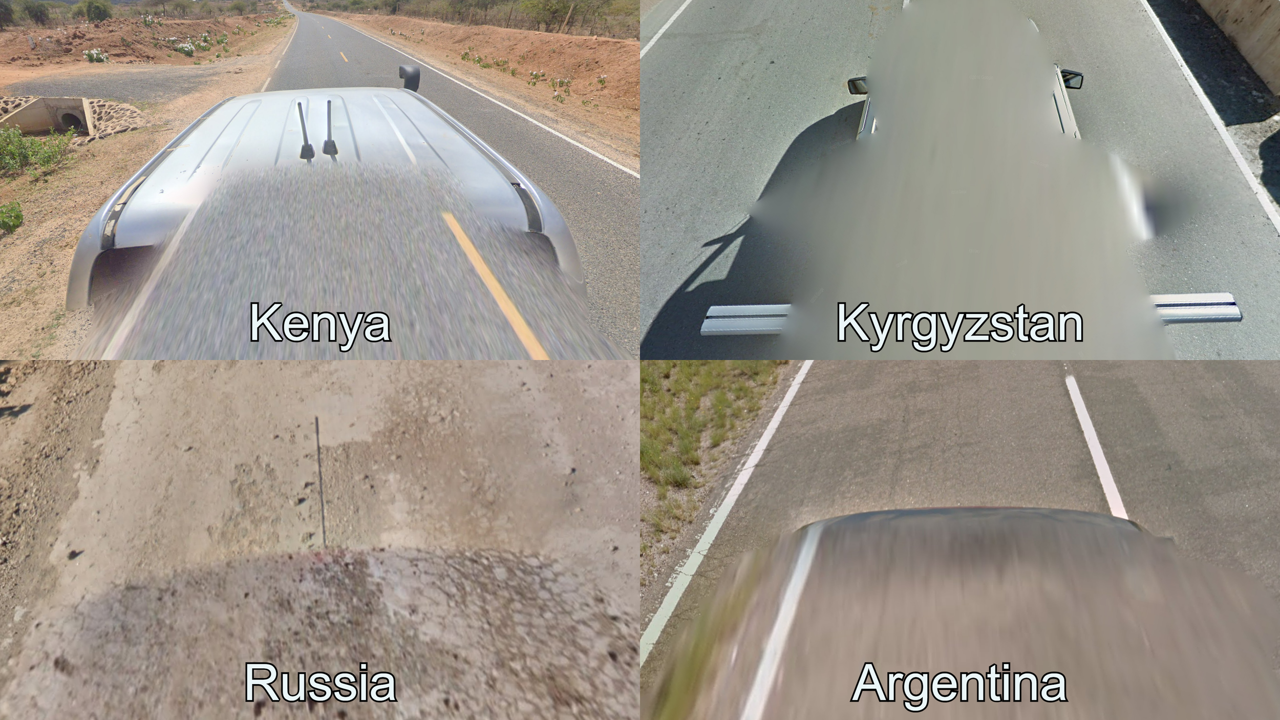
A grey truck, often featuring a snorkel, can be found in Gen 4 coverage in Kenya. All of the coverage in Kyrgyzstan features a car with a visible roofrack and rear view mirrors. A black car with a long antenna is very common in Russia. All of the Gen 3 coverage in Argentina was taken with a black car where the back is visible. In Latin America this car also exists in Uruguay and Peru.
In countries that have limited coverage, knowing the car or cars Google used to map the country can be a very easy way to recognize the country. In countries that do not receive frequent coverage, subtle differences in the Google Car are used to guess the right region or even the exact road.
It is important to mention that sometimes the way the community talks about certain cars can be confusing at first. For example, when people say that a “white car” only exists in Bolivia, Chile and Peru within Latin America, they are referring to this specific car in Generation 3 coverage. You can find a white car in Generation 4, as well as different white cars in Generation 3 that are blurred differently or have an antenna.
Season of the coverage
Sometimes, specific regions or countries receive all or most of their coverage during a single season. This can give the place a specific look. As with all of the clues mentioned in the “meta” section, this is especially common in low coverage countries. Even without paying active attention to the season, these countries will have a unique look that is in big part determined by the season, and therefore becomes an unavoidable coverage meta.

All of the coverage in Kyrgyzstan was taken between October and December, and therefore features a winter or fall look throughout the country. Most coverage in Andorra was taken during fall. Generation 4 coverage with snow in Turkey is limited to few places, such as south-east of Kayseri and around Erzurum. Generation 3 coverage with snow in Finland can only be found in the far north-west of Lapland.
As you can see in the examples above, seasonal metas in well-covered countries are frequently linked to the camera generation and/or the car meta. This way of regionguessing is not really recommended for beginner and intermediate players, and is mostly used by top players and players that specialize in a single country.
It is very important to remember that the season can give a very different look to a round of Geoguessr. Countries in temperate climates with four distinct seasons can look depressing in winter and vibrant in spring and summer. Likewise, tropical countries can look drastically different between dry and wet seasons.
Anything can be a clue
There is not a single type of clue that will work for every country, and likewise, there are also some very specific clues that only apply to a single country or a small region but can still be very effective.
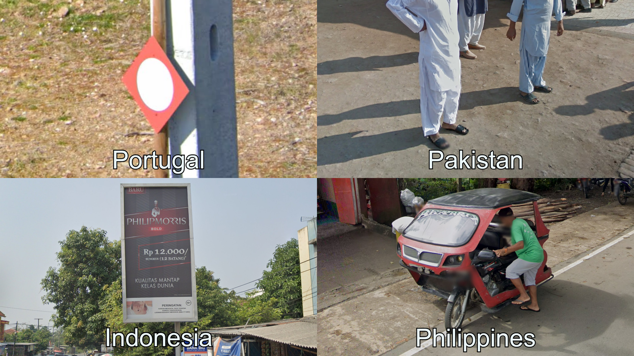
Portugal marks hunting grounds with red diamond-shaped signs with a white circle. An easy way to tell apart Pakistan trekkers from Indian trekkers is looking at men’s clothing. In Pakistan you will often see men wearing baggy pants, which is uncommon in India. Cigarette advertisement is banned in most of the world, however, it is extremely commonplace in Indonesia, to the point that it has become a way to easily confirm the country. Tuk-tuks are a very popular method of transportation in the Philippines and have distinct regional designs, the one pictured is unique to the island of Palawan.
As you can see, Geoguessr players have found very niche ways to help them make better guesses. However, sometimes they take it a step too far and start to see patterns where there are not…
Fake metas
When a clue that is not completely true spreads around in the community it becomes what is referred to as a “Fake meta”. These clues can range from completely inaccurate information, to something that works most of the time, so it’s important to be aware of them.
In some countries, infrastructure clues can be somewhat inconsistent. For example, poletops in Indonesia are a very good regionguessing meta. However, it is not uncommon to find a poletop in a place where it is not “supposed” to be. This does not mean that the clue is fake and you should not learn it, just that it is not 100% accurate.
A good example of a fake meta that kind of works is Estonian White Flowers. Seeing white flowers like those next to the road in a location that looks like a Baltic country became a clue for Estonia. These flowers, and similar looking ones, can be found all throughout the Baltics. Nevertheless, they are more common to find in Estonia, particularly in Generation 3 coverage, so if you are in a true toss-up and you see a good amount of white flowers, it can be a good idea to go Estonia.
Finally, in rare ocasions a completely inaccurate clue spreads around the community. These are very rare, and will mostly be called out quickly, but a very small amount have made their way into high profile video tutorials.